
Florida, Bahamas, and Bermuda Face Strengthening Atlantic Winds as Cold Front Pushes South, Triggering Hazardous Seas and Storm Concerns
FLORIDA KEYS, FLORIDA — Strong northerly to northeasterly winds continue to surge off the Atlantic, pushing across the Florida Peninsula, the Keys, and into the Bahamas, creating hazardous marine conditions and raising early-season storm concerns as a cold front drives unusually far south.
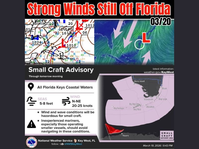
Strong Atlantic Winds Impact Florida and the Keys
A persistent flow of winds from the north and northeast is intensifying across the region, bringing sustained speeds of 20 to 25 knots along coastal waters. These winds are not only affecting Florida’s eastern coastline but are also extending deep into the Florida Keys.
The setup is being driven by a cold front that has dipped farther south than typical for this time of year, allowing cooler, denser air to funnel over warmer ocean waters — a combination that enhances wind strength and instability.
Small Craft Advisory Issued for Coastal Waters
The National Weather Service has issued a Small Craft Advisory covering all Florida Keys coastal waters through at least tomorrow morning. Sea heights are building between 5 to 8 feet, creating dangerous conditions for navigation.
Boaters, especially those operating smaller vessels, are being urged to avoid venturing into open waters. The combination of strong winds and elevated seas significantly increases the risk of capsizing or losing control.
Conditions Extend Toward the Bahamas
The same wind pattern is pushing southward into the Bahamas, where choppy seas and gusty conditions are also being observed. This widespread impact highlights how expansive the current system is, stretching well beyond Florida’s immediate coastline.
The Atlantic flow is creating a corridor of rough marine weather, affecting travel, fishing operations, and recreational boating across multiple regions.
Low Pressure System Drifting Toward Bermuda
Meteorological analysis indicates a weak low-pressure system attached to the front, which is expected to drift toward Bermuda in the coming days. As it moves eastward, it could enhance rainfall and wind activity in that region.
This area is also known for being a potential early-season development zone, where named storms can occasionally form before the official start of hurricane season.
Why This Pattern Matters Heading Into Spring
The current setup underscores how transitional weather patterns can still produce impactful conditions even as winter ends. The clash between cooler northern air and warmer ocean temperatures is a key driver of these strong wind events.
While no immediate tropical development is confirmed, the presence of a low-pressure system combined with favorable ocean conditions will be closely monitored.
What Residents and Mariners Should Expect Next
Wind conditions are expected to gradually ease as the system shifts eastward, but hazardous seas may linger for a short period. Mariners should continue monitoring advisories and avoid unnecessary travel until conditions improve.
For coastal communities across Florida, the Bahamas, and Bermuda, this event serves as an early reminder of how quickly Atlantic conditions can become dangerous.
As spring begins, forecasters will remain alert for any signs of further development, especially in regions known for early-season storm activity.

I’ve lived in Naperville long enough to see how quickly our community changes — from new developments downtown to sudden shifts in our Midwest weather. Reporting on Naperville news and daily forecasts gives me the chance to keep neighbors informed about what really matters. My goal is simple: deliver clear, timely updates so you always know what’s happening in our city and what to expect from the skies above.