
Ohio, Kentucky, West Virginia, Pennsylvania and Mid-Atlantic Brace for Severe Storm Threat With Damaging Winds, Large Hail, and Possible Tornadoes
COLUMBUS, OHIO — A growing severe weather threat is expected to unfold across the Ohio Valley and Mid-Atlantic, with forecasters warning of damaging winds, large hail, and the possibility of a few tornadoes as storms develop and track eastward.
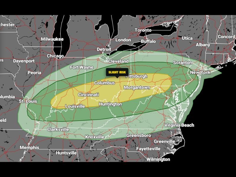
Slight Risk Zone Expands Across Multiple States
The latest outlook places a broad “slight risk” zone stretching from parts of Missouri and Illinois through Indiana, Ohio, Kentucky, West Virginia, and into Pennsylvania and New York.
Cities including Cincinnati, Columbus, Louisville, Huntington, Morgantown, and Pittsburgh sit within the higher concern corridor, where storm intensity is expected to be strongest.
Primary Threats: Wind, Hail, and Isolated Tornadoes
Meteorologists are highlighting several key hazards associated with this system. Damaging wind gusts are expected to be the most widespread threat, capable of downing trees and causing scattered power outages.
Large hail is also possible within stronger storm cells, particularly in areas where instability builds during the day. In addition, a few tornadoes cannot be ruled out, especially in zones where wind shear becomes more favorable.
Storm Timing and Development
Storms are expected to develop and intensify as warmer, unstable air interacts with an advancing system across the region. This setup is typical during seasonal transitions, when contrasting air masses collide.
The system is forecast to move from west to east, impacting the Ohio Valley first before pushing into the Mid-Atlantic, including areas near Scranton, New York City, and surrounding regions.
Wide Coverage Area Raises Concerns
One of the key concerns with this event is its geographic reach. The risk area spans several major population centers, increasing the potential for widespread impacts.
Even areas outside the core zone, including parts of Tennessee, Virginia, and North Carolina, may still experience thunderstorms, though severe conditions are more likely farther north.
Residents Urged to Stay Weather-Aware
Officials are encouraging residents across all impacted states to remain alert and prepared. With multiple hazards possible, having a way to receive warnings — especially during the evening or overnight hours — will be critical.
Preparedness steps include securing outdoor objects, reviewing safety plans, and staying updated with local forecasts as conditions evolve.
What Happens Next
As the system progresses eastward, conditions are expected to stabilize behind it, but not before delivering a potentially active period of severe weather.
Forecasters will continue to monitor the situation closely, particularly for any increase in tornado potential or expansion of the risk zones.
This developing system serves as another reminder that spring weather across the Ohio Valley and Mid-Atlantic can quickly turn dangerous, with multiple threats arriving in a short window of time.

I’ve lived in Naperville long enough to see how quickly our community changes — from new developments downtown to sudden shifts in our Midwest weather. Reporting on Naperville news and daily forecasts gives me the chance to keep neighbors informed about what really matters. My goal is simple: deliver clear, timely updates so you always know what’s happening in our city and what to expect from the skies above.