
Alabama Warm Dry Stretch Brings 80s Heat Across Birmingham Huntsville Montgomery With Limited Rain Until April
BIRMINGHAM, ALABAMA — A strong warm and dry weather pattern is settling across Alabama, pushing temperatures into the 80s and limiting rainfall chances across much of the state through the upcoming week.
The pattern is creating an early taste of summer across cities like Birmingham, Huntsville, and Montgomery, with sunshine dominating the forecast and only brief, isolated rain chances expected midweek.
Temperatures Surge Into the 80s Across Alabama
Forecasters indicate that much of Alabama will experience high temperatures in the 80s today and tomorrow, supported by mostly sunny to partly sunny skies.
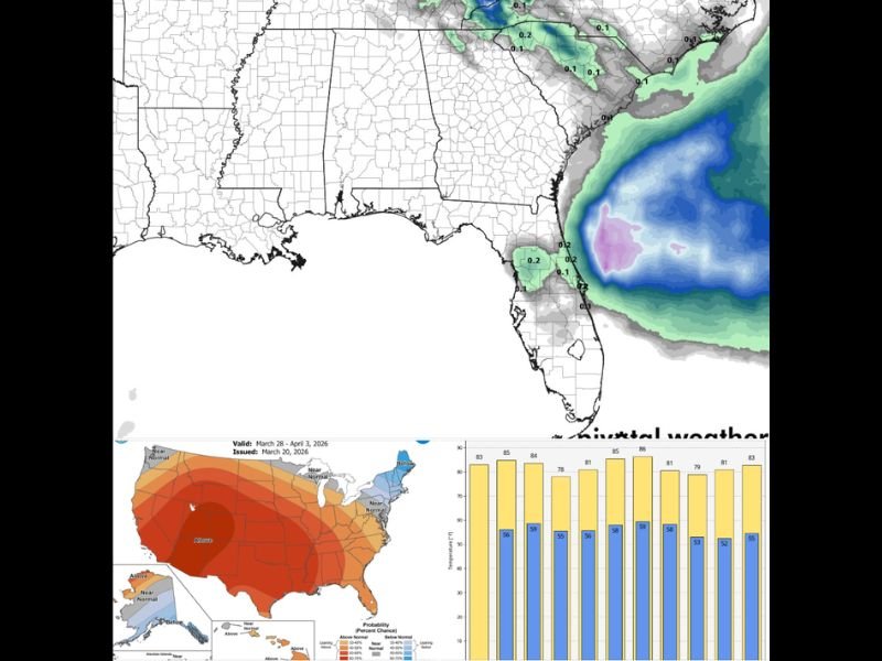
This warm surge is part of a broader regional trend, with above-normal temperatures expanding across much of the southern United States. The warmth is expected to feel more like late spring or early summer rather than late March.
Cities including Birmingham and Montgomery are likely to see consistent daytime highs in the low to mid-80s, while northern areas such as Huntsville remain just slightly cooler but still well above seasonal averages.
Brief Cooldown Before Another Warm Rebound
After the initial warm stretch, temperatures are expected to dip slightly into the 70s during the early part of the week, particularly Monday through Wednesday.
However, this cooldown will be short-lived. By Thursday and Friday, temperatures are forecast to climb back into the 80s statewide, reinforcing the ongoing warm pattern.
This fluctuation will not bring significant weather changes, as dry conditions are expected to dominate throughout.
Limited Rainfall Expected Across the State
Rain chances remain minimal across Alabama, with only small, isolated showers possible Tuesday or Wednesday.
These showers are expected to be scattered and brief, meaning most communities will stay dry throughout the week. There is no indication of widespread or organized storm systems impacting the region in the near term.
Forecast models suggest that the next meaningful, widespread rain or storm event may not arrive until early April, extending the dry stretch across the state.
Regional Outlook Shows Above-Normal Temperatures
Long-range outlooks continue to highlight above-average temperatures across much of the southern and central United States, including Alabama.
This reinforces the expectation of continued warmth beyond the immediate forecast period. The lack of precipitation combined with persistent warmth may begin to dry out soils in some areas if the pattern continues.
Meanwhile, parts of the Southeast coastline and nearby regions may see minor offshore precipitation, but this activity is expected to remain largely disconnected from Alabama’s inland weather pattern.
What This Means for Residents
For residents across Alabama, the forecast points to a prolonged stretch of warm, dry, and mostly sunny weather, ideal for outdoor activities but potentially concerning for those monitoring soil moisture and early-season dryness.
Travel conditions will remain favorable, with no major weather disruptions expected. However, residents should stay aware of changing conditions later in the month as the next storm system approaches. Meteorologists continue to monitor the evolving pattern, but for now, Alabama appears set to enjoy an extended period of calm, warm spring weather.

I’ve lived in Naperville long enough to see how quickly our community changes — from new developments downtown to sudden shifts in our Midwest weather. Reporting on Naperville news and daily forecasts gives me the chance to keep neighbors informed about what really matters. My goal is simple: deliver clear, timely updates so you always know what’s happening in our city and what to expect from the skies above.