
Ohio and Michigan Temperature Clash Brings 30s Near Great Lakes and Near 90 Degree Heat South of I 70 With Severe Storm Risk Sunday
OHIO AND MICHIGAN — A dramatic and potentially dangerous weather setup is unfolding across Ohio and Michigan this Sunday, where a sharp temperature divide will split the region between winter-like cold in the north and summer-like heat in the south.
Meteorologists are calling this a classic “winter meets summer” scenario, with conditions varying drastically over just a few hundred miles—creating both temperature shocks and an increased risk for severe storms.
Massive Temperature Divide Across the Region
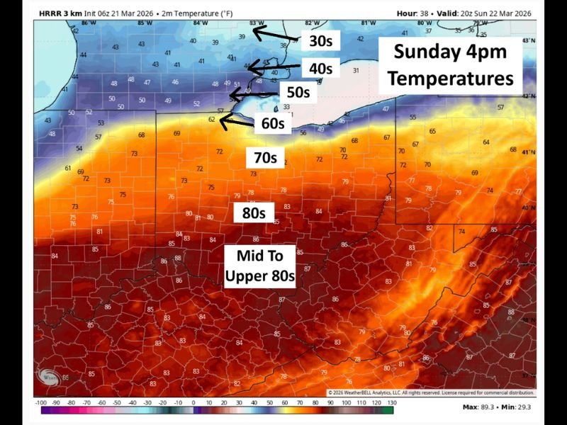
Forecast models show an extraordinary range in temperatures by Sunday afternoon, especially around 4 PM, when the contrast will be at its peak.
Northern Michigan, including areas near the Upper Peninsula and northern Lower Michigan, will remain stuck in the upper 30s to low 40s, holding onto a winter-like chill.
Moving southward into central Michigan, temperatures gradually rise through the 40s, 50s, and into the 60s, marking a clear transition zone.
By the time you reach southern Michigan and northern Ohio, readings climb into the 70s, before rapidly surging even higher across southern Ohio.
Southern Ohio Faces Summer-Like Heat
Communities across southern Ohio are expected to experience mid to upper 80s, with some locations approaching near 90 degrees—a stark contrast to the cold air just to the north.
Cities along and south of the Ohio River will feel more like early summer than late March, with warm, humid conditions adding to the intensity of the setup.
This sharp gradient—from 30s to near 90—will exist across a relatively short distance, making it one of the most extreme temperature spreads seen this season.
Severe Weather Risk Along and South of I 70
This clash of air masses is not just about temperatures—it also sets the stage for severe weather development, particularly along and south of the I-70 corridor.
Warm, unstable air surging northward will collide with colder air pushing south, creating the perfect environment for thunderstorms to intensify.
Areas across central and southern Ohio should be alert for the potential of:
- Strong to severe thunderstorms
- Gusty winds
- Rapid weather changes during the afternoon and evening
While exact storm timing and intensity will become clearer closer to Sunday, the setup already signals a need for heightened awareness.
Sharp Weather Boundary Creates Rapid Changes
One of the biggest concerns with this setup is how quickly conditions can change depending on location.
A short drive could take residents from chilly, jacket-required weather into near-summer heat. This sharp boundary will likely shift throughout the day, meaning some areas could experience rapid temperature swings within hours.
Northern areas will remain largely stable and cool, while southern zones will be much more volatile due to heat and instability.
What Residents Should Prepare For
Residents across Ohio and Michigan should prepare for a highly dynamic weather day. Those in northern areas should expect cooler, more stable conditions, while southern regions must stay weather-aware for potential severe storms.
Travelers especially should be cautious, as crossing the temperature boundary could bring sudden changes in conditions. Forecasters continue to monitor this developing system closely as Sunday approaches, urging residents to stay updated on the latest alerts and forecasts.

I’ve lived in Naperville long enough to see how quickly our community changes — from new developments downtown to sudden shifts in our Midwest weather. Reporting on Naperville news and daily forecasts gives me the chance to keep neighbors informed about what really matters. My goal is simple: deliver clear, timely updates so you always know what’s happening in our city and what to expect from the skies above.