
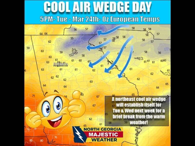
Georgia Weather Shift Brings Warm Start Then Cool Air Wedge Drops Temperatures Across Atlanta and North Georgia Midweek
ATLANTA, GEORGIA — A noticeable shift in weather is expected across North Georgia this week as warm, above-normal temperatures give way to a midweek cooldown driven by a developing “cool air wedge” pushing in from the northeast.
The transition will bring a brief break from the recent warmth, especially across areas like Atlanta and surrounding North Georgia communities.
Warm and Above Normal Temperatures Through Monday
North Georgia will continue to experience above-average temperatures through Monday (March 23), with conditions remaining mild and pleasant.
Daytime highs are expected to stay in the 60s to low 70s, with some warmer pockets pushing even higher. This extended warmth has created spring-like conditions across the region heading into the early part of the week.
Skies will remain mostly stable, with no major disruptions expected during this period.
Cool Air Wedge Arrives Tuesday and Wednesday
A key change begins Tuesday as a cool air wedge develops from the northeast, gradually pushing cooler air into North Georgia.
This setup is expected to:
- Lower daytime temperatures into the upper 50s to low 60s
- Increase cloud cover across the region
- Create a more stable and cooler weather pattern
The wedge effect occurs when cooler, denser air becomes trapped against the eastern side of the Appalachian Mountains, preventing warmer air from fully returning.
Forecast Models Show Uncertainty in Strength
Forecast models differ slightly on how strong this cooling pattern may become.
The European model (ECMWF) suggests a more modest cooldown, keeping temperatures relatively mild.
However, the American GFS model indicates a stronger wedge, which could lead to even cooler conditions than currently expected.
This difference means temperatures could vary depending on how the system evolves, and meteorologists are continuing to monitor the trend closely.
Brief Break From Warmth Before Pattern Stabilizes
Despite the cooldown, this will likely be a short-lived shift in the overall weather pattern.
The cooler conditions are expected to persist mainly through Tuesday and Wednesday, offering a temporary break from the warmth before temperatures gradually stabilize again later in the week.
No major storm systems are associated with this pattern, meaning precipitation chances remain limited, with clouds being the primary impact.
What Residents Should Expect
Residents across Atlanta and North Georgia should prepare for a two-phase weather pattern this week—warm and pleasant conditions early, followed by a cooler, cloudier midweek period.
While the temperature drop will not be extreme, it will be noticeable compared to the recent warmth. Layered clothing may be helpful as conditions shift.
Meteorologists will continue to track the strength of the cool air wedge and provide updates as the system develops further.

I’ve lived in Naperville long enough to see how quickly our community changes — from new developments downtown to sudden shifts in our Midwest weather. Reporting on Naperville news and daily forecasts gives me the chance to keep neighbors informed about what really matters. My goal is simple: deliver clear, timely updates so you always know what’s happening in our city and what to expect from the skies above.