
Colorado Denver and Front Range Heat Surge Brings Near 80 Degree Warmth Saturday Before Strong Cold Front Drops Temperatures 25 Degrees Sunday
DENVER, COLORADO — A sharp weather swing is unfolding across Colorado’s Front Range this weekend, with unusually warm temperatures Saturday quickly giving way to a cooler, wind-driven pattern by Sunday as a cold front moves through overnight.
The setup is bringing a brief burst of near-summer warmth followed by a noticeable cooldown and continued breezy conditions across Denver and surrounding areas.
Warm and Windy Conditions Build Saturday
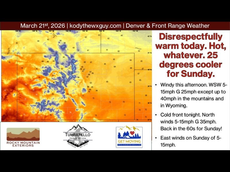
Saturday is expected to feel unseasonably warm, with temperatures climbing into the upper 70s and even low 80s across parts of the Front Range and Western Slope.
This warmth comes with an important caveat—increasing winds and elevated fire danger.
Winds out of the west-southwest at 5 to 15 mph, with gusts up to 25 mph, will impact most areas. In higher elevations and across Wyoming, gusts could reach up to 40 mph, creating more hazardous conditions.
The combination of warmth, dry air, and wind will heighten fire weather concerns throughout the day.
Strongest Winds Expected Saturday Afternoon
Forecasters indicate that the strongest winds will develop during the afternoon hours as the pressure gradient tightens ahead of an approaching cold front.
This will lead to periods of gusty conditions, especially in exposed and elevated areas. Residents should be cautious with outdoor activities that could spark fires, as conditions will be favorable for rapid spread.
Cold Front Arrives Overnight Bringing Sharp Cooldown
A cold front is expected to move through overnight, shifting winds and bringing a dramatic drop in temperatures by Sunday.
Behind the front:
- Winds turn northerly at 5 to 15 mph, with gusts up to 35 mph
- Temperatures fall by around 25 degrees compared to Saturday highs
- Most areas return to the 60s for Sunday
This marks a significant but short-lived change from the warm conditions experienced just a day earlier.
Sunday Brings Cooler and More Comfortable Weather
Despite the temperature drop, Sunday is expected to be relatively pleasant overall.
Winds will gradually shift to the east at 5 to 15 mph, and while some light upslope flow may develop, moisture with this system remains very limited.
That means no significant precipitation is expected, with the cooldown serving mainly as a reset after Saturday’s heat.
Extended Outlook Shows Continued Warmth and Uncertainty
Looking ahead, the Western Slope is expected to remain consistently warm, with temperatures in the upper 70s to low 80s through much of the upcoming week.
Across the broader region, weather patterns remain somewhat uncertain. High pressure is expected to rebuild, but occasional disturbances may pass through later in the week—particularly around Wednesday into Thursday—though current signals suggest limited moisture.
Longer-range outlooks hint at a potentially more active pattern returning late next weekend into early April, possibly bringing needed precipitation back to the region.
What Residents Should Expect
Residents across Denver and the Front Range should prepare for a two-day weather contrast—hot, dry, and windy conditions Saturday followed by a cooler, breezy Sunday.
The biggest concern remains fire danger during the warm and windy period, while Sunday offers more stable and comfortable conditions.
Officials continue to monitor evolving patterns, especially as models suggest changes heading into early April.

I’ve lived in Naperville long enough to see how quickly our community changes — from new developments downtown to sudden shifts in our Midwest weather. Reporting on Naperville news and daily forecasts gives me the chance to keep neighbors informed about what really matters. My goal is simple: deliver clear, timely updates so you always know what’s happening in our city and what to expect from the skies above.