
Severe Storms Fire Across Oklahoma After 2 PM Bringing Baseball-Size Hail, 75 MPH Winds, and Isolated Tornadoes From Western Oklahoma City Through Central Oklahoma Until Midnight
OKLAHOMA CITY, Okla. — All the ingredients are coming together for a significant and multi-hazard severe weather event across Oklahoma today, with storms expected to fire in western Oklahoma after 2 PM and push into central Oklahoma as early as 6 PM. Baseball-size hail, winds reaching 75 mph, and isolated tornadoes are all on the table between 3 PM and midnight — and a second wave of less severe but still dangerous storms could follow closely behind the first.
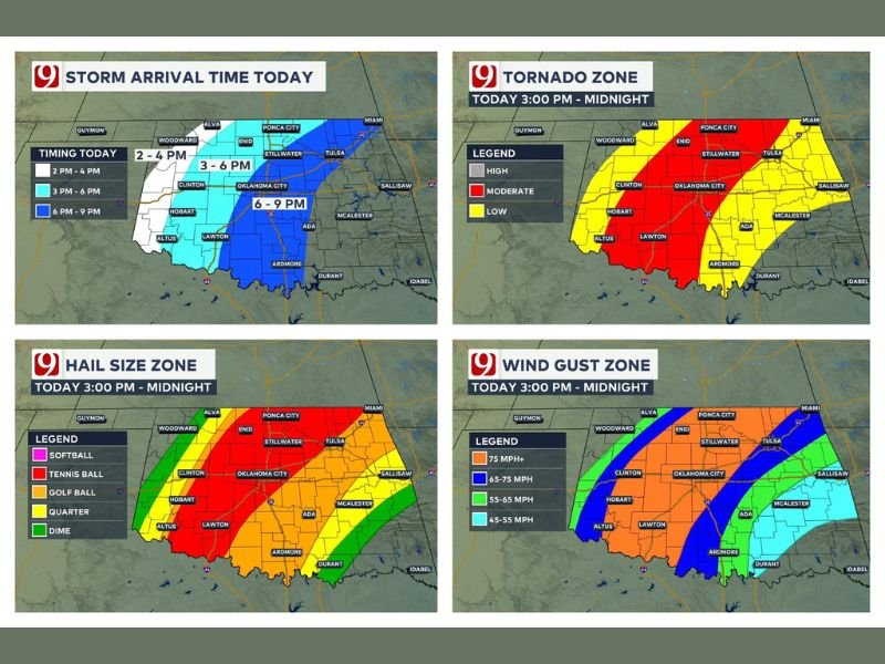
Storm Timing — What to Expect and When
The storm arrival timeline is well-defined across the state. Western Oklahoma sees the first storms between 2 and 4 PM, with central Oklahoma including Oklahoma City in the threat window between 3 and 6 PM. Eastern portions of the state face storm arrival between 6 and 9 PM, giving residents in Tulsa, McAlester, and Salusaw the latest but still dangerous window of severe activity through the overnight hours.
Tornado Zone — Moderate Risk for Central Oklahoma
The tornado threat map shows a moderate tornado risk — highlighted in red — centered over central Oklahoma including Oklahoma City, Clinton, Ardmore, and surrounding communities from 3 PM through midnight. A lower tornado risk in yellow extends outward to cover Ponca City, Stillwater, Tulsa, and eastern Oklahoma.
Isolated tornadoes are the expected outcome, but any tornado that develops in the moderate risk zone should be taken with full seriousness.
Baseball to Softball-Size Hail Possible in Western Oklahoma
The hail size zone map tells a striking story for western Oklahoma. The most extreme hail — softball size — is possible across the far western portions of the state near Hobart, Altus, and Lawton. Tennis ball-size hail is forecast for areas including Clinton and portions of central western Oklahoma, while golf ball-size hail extends through Oklahoma City and into the broader central corridor. Communities further east toward Tulsa can expect quarter to dime-size hail as storm intensity decreases eastward.
75 MPH Wind Gusts Threaten Central Oklahoma
Wind gusts exceeding 75 mph are forecast for a focused corridor through central Oklahoma — the highest wind gust category on today’s threat map. The 65 to 75 mph zone covers Oklahoma City and surrounding communities, while 55 to 65 mph gusts are expected further east toward Tulsa and McAlester. Even the outermost wind zone carries 45 to 55 mph gusts capable of causing tree damage and power outages.
Second Wave Could Follow With Quarter-Size Hail and 60 MPH Winds
After the first and most intense wave moves through, forecasters are tracking a potential second wave of less severe storms pushing in behind it. While not as dangerous as the initial round, this secondary wave could still produce quarter-size hail, 60 mph winds, and isolated tornado potential — meaning the threat does not simply end after the first line passes.
Residents statewide should stay weather aware all the way through midnight tonight. Stay with NapervilleLocal.com for the latest weather updates and local forecast coverage.

I’ve lived in Naperville long enough to see how quickly our community changes — from new developments downtown to sudden shifts in our Midwest weather. Reporting on Naperville news and daily forecasts gives me the chance to keep neighbors informed about what really matters. My goal is simple: deliver clear, timely updates so you always know what’s happening in our city and what to expect from the skies above.