
Major Severe Weather Outbreak Targets Chicago, Milwaukee, Des Moines, and Dallas This Afternoon Through Overnight With EF2+ Tornadoes, Baseball-Size Hail, and 65+ MPH Winds
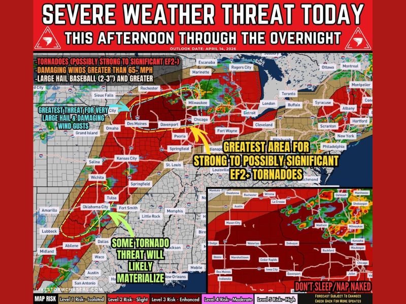
CHICAGO, Ill. — A significant and dangerous severe weather outbreak is unfolding across a massive corridor stretching from the Southern Plains all the way to the Great Lakes today, April 14, 2026. The greatest concern is focused across eastern Iowa, southern Wisconsin, and northern Illinois — where EF2+ tornadoes, baseball-size hail of 2 to 3 inches, and damaging winds exceeding 65 mph are all in play from this afternoon through overnight. Residents across the entire affected zone need to be alert, prepared, and ready to act immediately.
Eastern Iowa, Southern Wisconsin, and Northern Illinois Face the Greatest Tornado Threat
The highest tornado risk is concentrated in a corridor running from eastern Iowa through southern Wisconsin and into northern Illinois — directly through the Chicago and Milwaukee metro areas. This zone carries the greatest potential for strong to possibly significant EF2+ tornadoes, driven by enhanced low-level wind shear along a critical boundary where supercell thunderstorms will have maximum rotation potential.
The SPC has noted 30% hail and 10% tornado probabilities tied specifically to this corridor, making it the most dangerous area within an already large and serious severe weather setup.
Baseball-Size Hail and 65+ MPH Winds Threaten a Wide Area
Discrete supercells firing this afternoon are expected to produce very large hail reaching 2 to 3 inches — baseball size or larger — particularly across eastern Iowa into southern Wisconsin and northern Illinois. As storms grow upscale through the evening, damaging winds exceeding 65 mph become an increasing and widespread threat across a broader area stretching through the Midwest.
Communities from Des Moines, Davenport, Springfield, and Peoria through Chicago, Milwaukee, Fort Wayne, and Detroit all fall within the broader severe weather risk zone and should prepare for multiple hazards through the overnight hours.
Southern Plains Tornado Threat Develops After Midnight
Farther south across eastern Kansas, Oklahoma, and Texas, a separate tornado threat is expected to develop around and after midnight as the low-level jet strengthens overnight. The Dallas, Oklahoma City, Tulsa, and Wichita corridors all carry a meaningful tornado risk into the overnight hours, with isolated supercells capable of producing hail over 2 inches alongside the tornado threat.
Residents across the Southern Plains should not let the later timing create a false sense of security — the overnight tornado threat demands that shelter plans be firmly in place before bedtime.
Timeline: What to Expect and When
Storms begin developing this afternoon along a composite outflow boundary from eastern Iowa into southern Wisconsin and northern Illinois, and along the dryline from eastern Kansas into Oklahoma and Texas. Late afternoon through evening brings supercells with very large hail and tornado potential at their peak. Through the evening and overnight, storms grow upscale with an increasing and widespread wind threat while the tornado risk continues across both the Midwest and the Southern Plains.
Stay weather aware all the way through overnight — this outbreak does not end at sunset. Stay with NapervilleLocal.com for the latest weather updates and local forecast coverage.

I’ve lived in Naperville long enough to see how quickly our community changes — from new developments downtown to sudden shifts in our Midwest weather. Reporting on Naperville news and daily forecasts gives me the chance to keep neighbors informed about what really matters. My goal is simple: deliver clear, timely updates so you always know what’s happening in our city and what to expect from the skies above.