
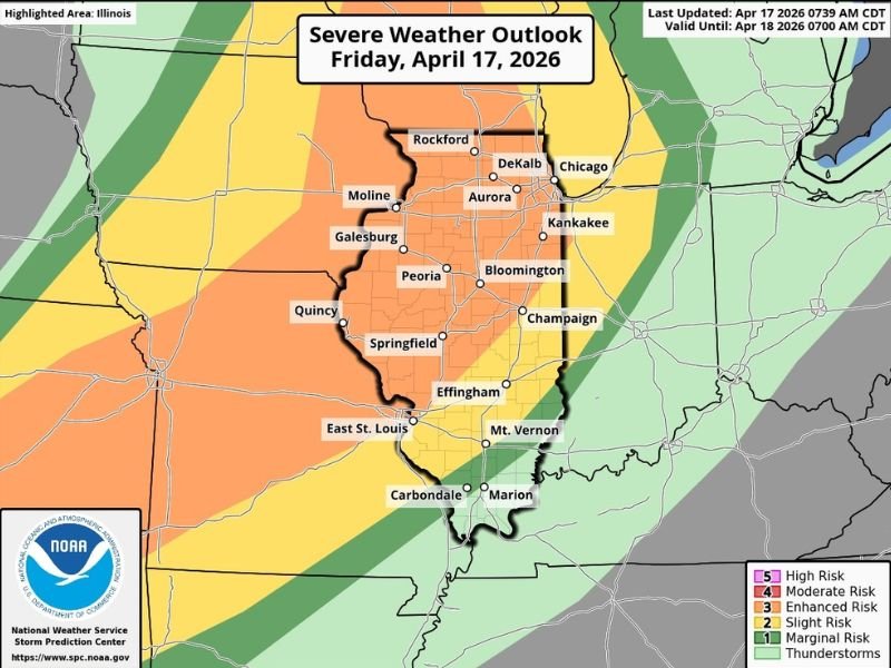
Powerful Squall Line Targeting Chicagoland, Rockford, and Aurora Tonight 7-9 PM With Widespread Damaging Winds, Flooding Rain, and Low Tornado Spin-Up Risk
CHICAGOLAND, ILLINOIS — A 9:12 AM Friday update confirms another active severe weather day is underway across Illinois on April 17, 2026, before a much-needed break arrives this weekend. While Chicagoland will remain capped through the daytime hours with no pre-frontal storms expected, tonight between 7 and 9 PM a powerful squall line will plow into the region bringing widespread damaging winds, heavy flooding rainfall, and a low but non-zero tornado spin-up risk.
Daytime Stays Capped but Atmosphere Loads Through the Afternoon
Temperatures will climb into the 80s this afternoon across Chicagoland, building significant instability into the atmosphere ahead of tonight’s squall line. However, a cap will keep storms suppressed during the daytime hours across the area, meaning residents will not see pre-frontal storm development before the main line arrives tonight.
Areas west of the Mississippi River do not benefit from the same cap, meaning storms will be firing out west through the afternoon as the squall line organizes and strengthens before eventually plowing into Chicagoland during the evening window.
Powerful Squall Line Arrives 7 to 9 PM Tonight
The main event for Chicagoland arrives between 7 and 9 PM tonight when the fully organized and powerful squall line pushes into the region. New overnight data has come in more volatile than previously anticipated, increasing confidence in a higher risk for widespread damaging winds across parts of the area alongside significant flooding rainfall.
The squall line is expected to be powerful and fast-moving as it sweeps through communities including Rockford, DeKalb, Chicago, Aurora, Kankakee, Moline, Galesburg, Peoria, Bloomington, Champaign, Springfield, and Effingham during the evening hours.
Damaging Straight-Line Winds Are the Primary Threat
The dominant hazard with tonight’s squall line is straight-line damaging winds rather than tornadoes. Forecasters are urging residents to treat any wind warnings tonight with the same seriousness as a tornado warning, as the straight-line winds associated with this powerful squall line could be damaging and destructive across a wide area.
The Severe Wind Outlook for Friday shows elevated wind probabilities across the entire Illinois corridor from Rockford southward through Springfield and into southern Illinois. Wind damage to trees, power lines, and structures is the most likely widespread impact from tonight’s event.
Tornado Risk Remains Low but Cannot Be Ruled Out
While the linear nature of the squall line keeps the tornado threat significantly lower compared to areas further west, forecasters are not completely dismissing the possibility. A brief spin-up tornado associated with QLCS mesovortices along the leading edge of the line cannot be ruled out as the system pushes through.
Big and powerful tornadoes are considered unlikely across Chicagoland given the squall line structure, with the better tornado chances remaining west of the region where more discrete supercell activity is expected through the afternoon and evening hours.
Frost Concerns Arrive Saturday and Sunday Night
Behind the departing squall line, drastically colder temperatures will sweep into the region by tomorrow. Frost concerns are expected both Saturday night and Sunday night as the cold air mass settles firmly into place across Chicagoland following the frontal passage.
With the recent supercharged growing season well underway, some plant damage is possible during the frost periods this weekend. Residents with gardens, landscaping, or sensitive outdoor plants should take protective measures before Saturday night arrives. Temperatures will then warm up again heading into next week. Stay with NapervilleLocal.com for the latest weather updates and local forecast coverage.

I’ve lived in Naperville long enough to see how quickly our community changes — from new developments downtown to sudden shifts in our Midwest weather. Reporting on Naperville news and daily forecasts gives me the chance to keep neighbors informed about what really matters. My goal is simple: deliver clear, timely updates so you always know what’s happening in our city and what to expect from the skies above.