
EF2+ Tornado Outbreak Threatening Southern Wisconsin, Northern Illinois, and Eastern Iowa Today With Gorilla Hail and Damaging Winds From Oklahoma to Lake Superior
MIDWEST — A widespread severe weather and tornado outbreak is on tap today across a massive corridor stretching from Oklahoma all the way north to Lake Superior. The greatest tornado potential is focused across southern Wisconsin, northern Illinois, and eastern Iowa where EF2 or stronger tornadoes are possible. Supercells across the northern zones could begin maturing as early as 1 PM, making immediate preparedness critical for millions of residents across the entire risk area.
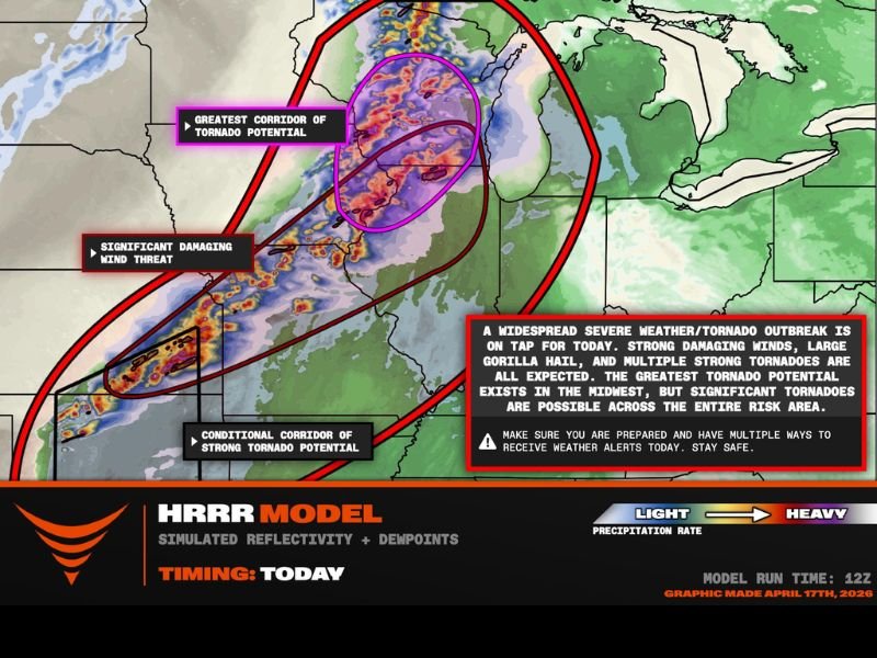
Greatest Tornado Corridor Targets Southern Wisconsin and Northern Illinois
The greatest corridor of tornado potential is centered across southern Wisconsin and northern Illinois, highlighted on the outlook map with the highest concentration of storm energy. This zone faces the most significant risk of organized and long-tracked tornadoes, including the possibility of violent EF2 or greater events.
Supercells in this northern corridor are expected to begin maturing as early as 1 PM, meaning the tornado threat could arrive earlier than many residents may anticipate. Anyone in southern Wisconsin, northern Illinois, and eastern Iowa should treat today’s threat with the utmost seriousness and have shelter plans ready before midday.
Conditional Strong Tornado Threat Extends South to Oklahoma
South of the primary outbreak zone, a conditional corridor of strong tornado potential extends all the way down through the central Plains to Oklahoma. A significant damaging wind threat also develops across this southern zone, where a damaging wind bag will push southward as storms organize through the afternoon and evening hours.
While the tornado threat in this southern corridor is more conditional compared to the northern zone, it is far from zero. Residents from Oklahoma northward through Kansas, Missouri, and Iowa should remain weather-aware throughout the day and have multiple ways to receive alerts active at all times.
Gorilla Hail and Damaging Winds Expected Across the Full Risk Area
Beyond the tornado threat, two additional significant hazards are in play across the entire risk corridor today. Large gorilla hail — an informal term used by meteorologists for extremely large and destructive hailstones — is expected to accompany the strongest supercells across the outbreak zone.
Significant damaging winds represent the third major threat, particularly across the southern portion of the risk area where the squall line and wind bag are expected to develop. The combination of all three hazards across such a wide geographic area makes today’s setup one of the more comprehensive severe weather events of the season.
Watches and Warnings Expected From Oklahoma to Lake Superior
Severe weather watches and warnings are expected to be issued across an enormous stretch of the country today, running from Oklahoma northward all the way to Lake Superior. Residents across this entire corridor should stay tuned to local alerts and not assume that the threat is limited only to areas currently under active watches.
The outbreak setup is dynamic and conditions can shift quickly as supercells mature and the squall line organizes through the afternoon. Staying connected to updated forecasts throughout the day is essential for anyone within or near the outlined risk zones.
Prepare Now and Have Multiple Ways to Receive Alerts
With supercells potentially maturing as early as 1 PM across the northern zones, there is limited time remaining to finalize severe weather preparations. Identify your shelter location, ensure battery backups and emergency supplies are ready, and activate multiple alert systems including weather apps and wireless emergency alerts on mobile devices.
Do not rely on a single source of warning information during today’s outbreak. The speed at which conditions can develop demands that residents across the entire risk area from Oklahoma to Lake Superior remain actively engaged with weather updates throughout the day and into the evening. Stay with NapervilleLocal.com for the latest weather updates and local forecast coverage.

I’ve lived in Naperville long enough to see how quickly our community changes — from new developments downtown to sudden shifts in our Midwest weather. Reporting on Naperville news and daily forecasts gives me the chance to keep neighbors informed about what really matters. My goal is simple: deliver clear, timely updates so you always know what’s happening in our city and what to expect from the skies above.