
Much-Needed Rain Delivers Up to 2.4 Inches Across Western Kentucky, Northwest Tennessee, and Southeast Missouri Thursday With More Relief Possible Saturday
WESTERN KENTUCKY, NORTHWEST TENNESSEE, AND SOUTHEAST MISSOURI — Thursday evening’s storms delivered a welcome and much-needed dose of rainfall across Western Kentucky, Northwest Tennessee, and Southeast Missouri, with several spots picking up anywhere from near half an inch to over one inch of rain.
The rainfall represents a meaningful start toward easing drought conditions across a region that has been running critically dry, with more rain potentially on the way Saturday to continue the recovery effort.
Sikeston and Surrounding SEMO Lead Rainfall Totals
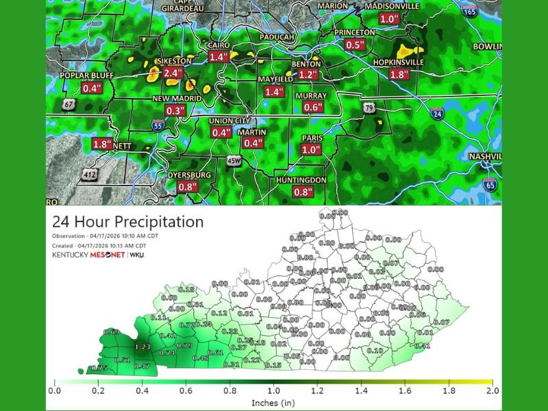
Southeast Missouri saw some of the highest rainfall totals from Thursday evening’s storm activity. Sikeston recorded 2.4 inches, leading all reported totals across the three-state region and providing significant drought relief to that community.
Cairo picked up 1.4 inches and Mayfield recorded the same amount, while Nett reported 1.8 inches. New Madrid received 0.3 inches and Poplar Bluff picked up 0.4 inches, with Dyersburg recording 0.8 inches across the broader SEMO and northwest Tennessee corridor.
Western Kentucky Picks Up Meaningful Totals
Across Western Kentucky, rainfall totals were widespread and meaningful for a region desperately in need of moisture. Hopkinsville led the Kentucky totals with 1.8 inches recorded, followed by Benton at 1.2 inches and Madisonville at 1.0 inches.
Princeton received 0.5 inches and Murray picked up 0.6 inches, while Paris recorded a solid 1.0 inch. Kentucky Mesonet data verified rainfall totals across western counties of the state ranging from 0.47 inches near the far western tip up to 1.23 inches across the most heavily impacted zones, with amounts dropping off quickly heading east across the state.
Kentucky Mesonet Data Confirms Western Focus of Rainfall
The Kentucky Mesonet precipitation map dated April 17, 2026 clearly shows the highly localized nature of Thursday evening’s rainfall, with virtually all of the meaningful precipitation confined to the far western counties of Kentucky. Values of 0.69 to 1.23 inches are confirmed across the westernmost counties, with totals dropping sharply to trace amounts or zero across central and eastern Kentucky.
This sharp gradient highlights both the localized benefit of Thursday’s storms and the ongoing dry conditions that continue to grip the majority of Kentucky beyond the immediate western border counties.
Drought Relief Welcome but More Rain Still Needed
While Thursday evening’s rainfall totals are a genuinely positive development for communities across Western Kentucky, Northwest Tennessee, and Southeast Missouri, forecasters are clear that one round of rain is not sufficient to meaningfully erase the deep moisture deficits accumulated over weeks and months of drought conditions.
The region needs sustained and repeated rainfall events over an extended period to begin making a real dent in drought conditions that have been described as among the worst on record for this time of year across much of the nation.
More Rain Possible Saturday to Continue Recovery
The next opportunity for additional drought-busting rainfall arrives Saturday, with forecasters hopeful that another round of precipitation will push through the region and build on the progress made by Thursday evening’s storms. Any additional rainfall will be welcomed across all three states as communities continue working toward meaningful drought recovery heading deeper into spring. Stay with NapervilleLocal.com for the latest weather updates and local forecast coverage.

I’ve lived in Naperville long enough to see how quickly our community changes — from new developments downtown to sudden shifts in our Midwest weather. Reporting on Naperville news and daily forecasts gives me the chance to keep neighbors informed about what really matters. My goal is simple: deliver clear, timely updates so you always know what’s happening in our city and what to expect from the skies above.