
Excessive Rainfall Threat Targeting Houston and Galveston Today and Tonight With Isolated Locations Possibly Seeing 3 or More Inches of Rain
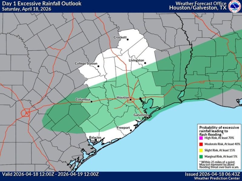
HOUSTON AND GALVESTON, TEXAS — An updated rainfall outlook for Saturday, April 18, 2026 is raising expectations for heavier than previously anticipated precipitation across the Houston and Galveston region later today and tonight. The Day 1 Excessive Rainfall Outlook issued by the Weather Forecast Office Houston/Galveston shows a Marginal Risk of flash flooding across a broad corridor covering Houston, Galveston, Freeport, Columbus, and surrounding communities. Isolated locations across Houston may see 3 or more inches of rainfall as showers show signs of overperforming initial expectations.
Showers Showing Signs of Overperforming Today
The key headline from this updated outlook is that incoming data suggests today’s showers may deliver more rainfall than originally forecast. Isolated locations across Houston specifically have been flagged as potentially picking up 3 or more inches of rain before the system exits the region by Sunday.
While that threshold may not be reached everywhere, the possibility of localized heavy rainfall totals means that flash flooding cannot be dismissed across the Houston metro and surrounding areas during the afternoon and overnight hours today.
Marginal Flash Flood Risk Covers Houston to Galveston Corridor
The Excessive Rainfall Outlook valid from April 18 through April 19, 2026 places the Houston and Galveston corridor under a Marginal Risk designation, indicating at least a 5% probability of excessive rainfall leading to flash flooding across the outlined zone. The risk area stretches from areas near Columbus and College Station eastward through Houston and down to Galveston and Freeport along the Gulf Coast.
The Marginal Risk zone also extends northward toward Livingston and Crockett, covering a broad swath of Southeast Texas during the valid period. Residents across this entire corridor should remain aware of the flash flood potential through the overnight hours tonight.
Houston Metro Sits in the Highest Concern Zone
Within the broader Marginal Risk area, the Houston metro sits in the darkest shaded zone on the outlook map, indicating the highest concentration of excessive rainfall probability within the overall risk area. The combination of urban drainage infrastructure, already moist soils from recent rainfall, and the potential for 3-plus inch totals in isolated spots makes the Houston metro the area of greatest concern for localized flash flooding today and tonight.
Residents in low-lying areas, near bayous, or in areas with a history of flooding should pay particularly close attention to rainfall rates this afternoon and evening and be prepared to move to higher ground if water begins rising rapidly.
Rainfall Window Runs Through Sunday Morning
The excessive rainfall outlook is valid from noon Saturday through noon Sunday, covering a full 24-hour window of potential heavy rainfall across Southeast Texas. The bulk of the heavier activity is expected during the afternoon and overnight hours today, with the system gradually exiting the region heading into Sunday morning.
Residents should avoid unnecessary travel after dark tonight if heavy rain is occurring in their area, as flooded roadways are the leading cause of weather-related fatalities during flash flooding events. Never attempt to drive through standing or flowing water on roadways regardless of how shallow it may appear. Stay with NapervilleLocal.com for the latest weather updates and local forecast coverage.

I’ve lived in Naperville long enough to see how quickly our community changes — from new developments downtown to sudden shifts in our Midwest weather. Reporting on Naperville news and daily forecasts gives me the chance to keep neighbors informed about what really matters. My goal is simple: deliver clear, timely updates so you always know what’s happening in our city and what to expect from the skies above.