
Colorado Warms From Teens Saturday to 80s by Monday East of Continental Divide With More Meaningful Precipitation Possible Next Week
COLORADO — A cold but recovering weekend is underway across Colorado this Saturday morning after yesterday’s spicy cold front sent temperatures plunging into the teens and 20s across much of the state. The good news is that a steady and significant warmup is on the way, with highs rebounding into the 50s and low 60s east of the Continental Divide today before pushing into the 70s Sunday and widespread 80s by Monday. A more active weather pattern then returns for the second half of next week with several opportunities for meaningful precipitation.
Cold Saturday Morning Gives Way to a Pleasant Afternoon
Most of Colorado woke up this Saturday to temperatures in the teens and 20s, with even colder readings up in the mountains following yesterday’s cold frontal passage. Despite the cold start, afternoon highs will rebound nicely into the 50s to low 60s east of the Continental Divide, with cooler readings in the mountains and temperatures near 60 on the western slope.
Wind will be breezy but manageable today, with northwest winds of 5 to 15 MPH and gusts up to 25 MPH expected through about 5 PM across the Divide, Wyoming, Nebraska, and the eastern plains before gradually diminishing through the evening hours.
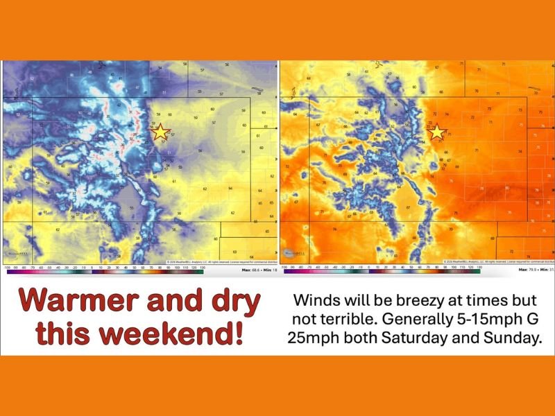
Sunday Warms Into the 70s as Southwest Flow Returns
A significant pattern shift arrives Sunday as southwest flow cranks up across the region, pushing temperatures into the 70s for a large portion of the state. Areas along Highway 50 could see readings approaching 80 degrees, while the western slope climbs to near 70. The warmup will make for an exceptionally pleasant late April Sunday across Colorado after the cold start to the weekend.
Winds will remain breezy at times Sunday, generally running 5 to 15 MPH with gusts to 25 MPH, but conditions will not be severe enough to significantly impact outdoor plans across most of the state during the afternoon hours.
Monday Brings Widespread 80s East of the Divide
The warmup continues and intensifies heading into Monday, with widespread highs in the 80s expected east of the Continental Divide and temperatures near 80 on the western slope. Monday will represent the peak of the warm spell for the region before the pattern begins to shift again heading into the middle of next week.
A small amount of moisture will begin sneaking in from the south and west by Monday into Tuesday, bringing a few extra clouds and the possibility of light showers or sprinkles. The precipitation will not be significant but will be a welcome addition to help maintain some humidity across the region heading deeper into the week.
Temperatures Peak Wednesday Before Active Pattern Returns
Temperatures are likely to peak on Wednesday ahead of a meaningful shift back toward a more active weather pattern for the second half of next week and into the following weekend. The transition sets up what forecasters are describing as several opportunities for more meaningful precipitation during the 5 to 10 day window.
The details of the precipitation events during that window will become clearer as the week progresses, but the overall trend looks promising for areas across Colorado that have been dealing with dry conditions and could benefit from repeated rainfall and mountain snowfall opportunities heading into late April and early May. Stay with NapervilleLocal.com for the latest weather updates and local forecast coverage.

I’ve lived in Naperville long enough to see how quickly our community changes — from new developments downtown to sudden shifts in our Midwest weather. Reporting on Naperville news and daily forecasts gives me the chance to keep neighbors informed about what really matters. My goal is simple: deliver clear, timely updates so you always know what’s happening in our city and what to expect from the skies above.