
Historic Number of Tornado Warnings Blanket Central Illinois Including Peoria, Bloomington, and Normal Friday Night With 85 MPH Gusts and Multiple Confirmed Tornadoes
CENTRAL ILLINOIS — An unprecedented number of tornado warnings were issued across central Illinois on Friday night, April 17, 2026, in what is being described as a historic single-event warning total that in some cases exceeded the number of tornado warnings typically issued across an entire year.
The squall line responsible produced frequent wind gusts of 60 to 75 MPH with a maximum gust of 85 MPH reported in Normal. Several mesovortices spun up along the line producing the extraordinary number of tornado warnings, and while several tornadoes are confirmed to have occurred, the official count is still pending completion of National Weather Service damage surveys.
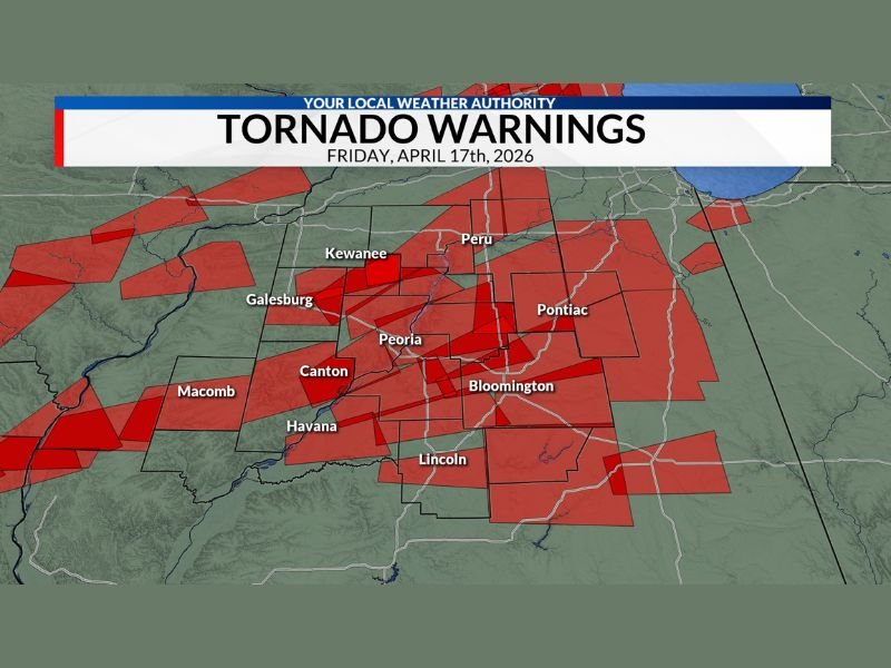
Warning Map Shows Central Illinois Completely Covered
The tornado warning map from Friday night, April 17, 2026 shows an almost unbroken wall of red warning polygons blanketing central Illinois from corner to corner. Communities including Peoria, Bloomington, Pontiac, Peru, Kewanee, Galesburg, Canton, Havana, Lincoln, and Macomb all fell under tornado warnings during the event.
The sheer density and overlap of warning polygons across the region visually captures just how relentless and widespread the tornado warning activity was throughout the evening. Forecasters and weather communicators covering the event described it as unlike anything they had experienced in terms of the volume of simultaneous and successive tornado warnings issued across such a concentrated geographic area.
Squall Line Produced 60-85 MPH Winds and Multiple Mesovortices
The squall line that swept through central Illinois Friday night was producing frequent wind gusts of 60 to 75 MPH along its leading edge, with a peak gust of 85 MPH recorded in Normal — a reading that falls into the range of weak tornado wind speeds and underscores just how powerful the straight-line wind component of the event was.
Several mesovortices developed and spun up along the length of the squall line as it moved through the region, and it is these rotating circulations embedded within the line that generated the extraordinary number of tornado warnings issued throughout the evening. Mesovortex-produced tornadoes from squall lines tend to be brief and low-topped but can still produce significant damage across their paths.
Multiple Tornadoes Confirmed but Official Count Still Pending
Multiple tornadoes are known to have occurred across central Illinois during Friday night’s event, but the exact number and intensity ratings remain unknown pending completion of NWS damage surveys across the affected area. The survey process is expected to take considerable time given the large geographic area that was impacted and the number of potential tornado paths that need to be walked and assessed by survey teams.
National Weather Service offices in Central Illinois, Chicago, and Quad Cities are all expected to contribute to the survey effort given the broad footprint of the event. Final tornado counts, track lengths, widths, and EF ratings will be released as each survey is completed over the coming days.
Event Sets Personal Record for Single-Event Tornado Warning Coverage
Meteorologists covering the event noted that Friday night’s tornado warning total across central Illinois exceeded the number of tornado warnings they typically cover over an entire calendar year, putting the historic nature of the event into sharp personal and professional perspective.
The dedication and accuracy of NWS Central Illinois, NWS Chicago, NWS Quad Cities, and local Emergency Management Agency offices throughout the event was credited with providing timely and accurate warnings that gave residents the best possible chance to seek shelter ahead of each warned storm. Stay with NapervilleLocal.com for the latest weather updates and local forecast coverage.

I’ve lived in Naperville long enough to see how quickly our community changes — from new developments downtown to sudden shifts in our Midwest weather. Reporting on Naperville news and daily forecasts gives me the chance to keep neighbors informed about what really matters. My goal is simple: deliver clear, timely updates so you always know what’s happening in our city and what to expect from the skies above.