
Very Unstable Air and Surface Low Pressure Locking Onto Northeast Nebraska Thursday 7 PM Setting Stage for Significant Storm Development
NORTHEAST NEBRASKA — The Thursday 7 PM run of the European weather model is showing a significant and concerning atmospheric setup developing over northeast Nebraska, with very unstable air in place and active storm development already underway across the region by that time.
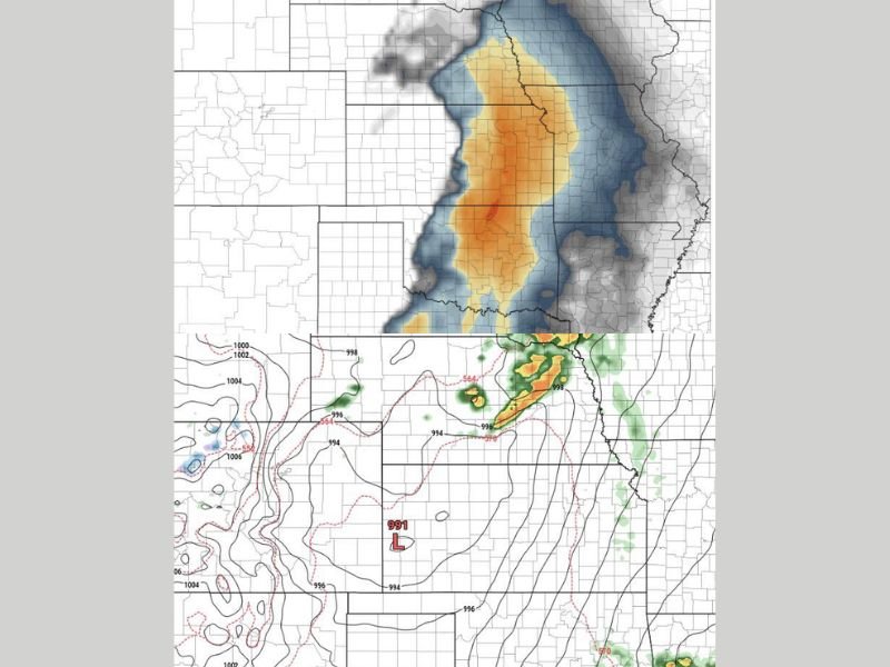
The instability field on the model output shows a concentrated and intense orange and red core of atmospheric instability centered directly over northeast Nebraska, surrounded by a broader field of elevated instability extending across the state and into neighboring Iowa and South Dakota.
Very Unstable Air Mass Concentrated Over Northeast Nebraska
The European model instability data for Thursday evening shows one of the more impressive setups seen in recent model runs for the region. The deepest and most intense instability is focused in a concentrated core over northeast Nebraska, shown in the darkest orange and red shading on the model output map.
This level of instability provides significant fuel for storm development and intensification during the Thursday evening hours. When very unstable air of this magnitude is in place, storms that develop within the unstable zone have the potential to rapidly intensify and become organized, increasing the probability of severe weather impacts across the affected area.
Broader Instability Field Extends Into Iowa and South Dakota
Surrounding the intense core over northeast Nebraska, a broader field of elevated atmospheric instability extends outward across a large geographic area. The instability field shown on the European model covers much of Nebraska, extending northward into South Dakota and eastward into Iowa, indicating that the favorable atmospheric environment for storm development is not limited to a small or localized area on Thursday evening.
This broader instability footprint suggests that any storms initiating over the most unstable core in northeast Nebraska could sustain themselves and potentially grow as they move into surrounding areas, expanding the geographic footprint of the Thursday evening storm threat beyond just the initial development zone.
Surface Low Pressure System Adds to the Threat Picture
The surface analysis portion of the European model shows a 991 millibar low pressure system positioned across the central Plains region, providing additional forcing and lift to support storm development across Nebraska and surrounding states Thursday evening. Low pressure systems of this depth are capable of generating significant wind shear and convergence that further enhances the severe weather environment when combined with the very unstable air mass already in place.
The positioning of the surface low relative to the instability core over northeast Nebraska creates a favorable alignment of atmospheric ingredients that forecasters closely monitor when evaluating severe weather potential for any given event.
Thursday Evening Storm Threat Part of Broader Pattern Return
This European model data for Thursday evening is consistent with the broader return of severe weather potential that has already been flagged across the southern Plains and Midwest for Thursday and Friday this week. The very unstable air over northeast Nebraska shown in this model run adds confidence to the concern that Thursday evening will not be a quiet weather day for portions of the central Plains.
Residents across northeast Nebraska and surrounding areas should monitor updated forecasts closely through the week as the Thursday evening storm potential comes into sharper focus and additional model data refines the details of the developing severe weather threat. Stay with NapervilleLocal.com for the latest weather updates and local forecast coverage.

I’ve lived in Naperville long enough to see how quickly our community changes — from new developments downtown to sudden shifts in our Midwest weather. Reporting on Naperville news and daily forecasts gives me the chance to keep neighbors informed about what really matters. My goal is simple: deliver clear, timely updates so you always know what’s happening in our city and what to expect from the skies above.