
Widespread 70s and Dry Conditions Across Colorado and Denver Front Range Sunday With Low-Level Jet Bringing 40 MPH Gusts to Eastern Plains After Sunset
COLORADO AND DENVER FRONT RANGE — A gorgeous and dry Sunday is lined up for Colorado and the Denver Front Range on April 19, 2026, with widespread temperatures in the 70s and variable winds of 5 to 15 MPH making for a pleasant late April day across most of the region. The calm daytime conditions will give way to a breezy evening on the eastern Plains after sunset as the low-level jet kicks in, bringing gusts up to 40 MPH through the overnight hours.
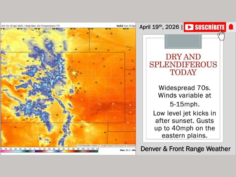
Widespread 70s and Dry Conditions Dominate Sunday
Temperature data valid for Sunday April 19 shows warm and comfortable readings spreading broadly across Colorado east of the Continental Divide, with widespread 70s covering the eastern Plains, Denver metro, and Front Range communities. The western slope and higher terrain will see cooler readings, but overall conditions across the state are as pleasant as they have been in recent weeks.
Winds will remain variable at 5 to 15 MPH through the daylight hours, keeping conditions calm and comfortable for any outdoor plans across the region. No precipitation is expected east of the Continental Divide, with only some extra cloud cover and the possibility of light mountain showers or sprinkles on the western slope as a small amount of mid and high-level moisture sneaks in from the south and west.
Low-Level Jet Kicks In After Sunset Bringing 40 MPH Gusts to Eastern Plains
The pleasant daytime conditions will shift noticeably after sunset Sunday evening as the low-level jet activates across the eastern Plains. Wind gusts up to 40 MPH are expected to develop across the eastern Plains corridor after dark, making for a considerably blustery overnight period compared to the calm and gorgeous daytime conditions.
Residents across the eastern Plains should be aware of the wind shift after sunset and secure any lightweight outdoor items before dark to prevent wind damage or displacement overnight.
Warm and Dry Pattern Continues Into Early Week
The favorable weather pattern extends through the first half of the week across Colorado, with warm and dry conditions expected to persist through at least Wednesday. Some extra clouds will filter in at times as mid and high-level moisture continues sneaking in from the south and west, but no measurable precipitation is anticipated east of the Continental Divide during this period.
A more potent storm system will roll through the northern Plains Wednesday into Thursday, but it is expected to track far enough north to keep meaningful precipitation away from Colorado. The primary impact from that system will be some gusty winds and noticeable barometric pressure swings across the region as it passes.
Increasing Precipitation Chances Possible Late Week Into Weekend
Toward the end of the week and into the weekend, the weather pattern begins showing some more interesting trends for Colorado. A series of troughs moving into the central and northern Plains is expected to increase precipitation chances across Colorado, including the Front Range and mountain areas.
The timing and specific impacts of these late-week precipitation opportunities are still being refined, with forecasters monitoring the details closely as the systems approach. Updated forecasts will be issued as the week progresses and the picture becomes clearer for what could be a more active end to April across the region. Stay with NapervilleLocal.com for the latest weather updates and local forecast coverage.

I’ve lived in Naperville long enough to see how quickly our community changes — from new developments downtown to sudden shifts in our Midwest weather. Reporting on Naperville news and daily forecasts gives me the chance to keep neighbors informed about what really matters. My goal is simple: deliver clear, timely updates so you always know what’s happening in our city and what to expect from the skies above.