
Strong El Niño Expected This Summer Points to Quieter Atlantic Hurricane Season With Major Hurricane Count Potentially Dropping From 18 to Just 7 Compared to La Niña Years
GULF AND CARIBBEAN REGION — With a strong El Niño pattern expected to dominate this summer, historical comparisons drawn from the five strongest El Niño years versus the five strongest La Niña years reveal a dramatic difference in Atlantic hurricane activity, pointing toward a relatively quieter season ahead for the Gulf Coast, Caribbean, and Florida. While no hurricane season can be dismissed entirely, the atmospheric dynamics tied to strong El Niño conditions have historically cut major hurricane production by more than half compared to strong La Niña years.
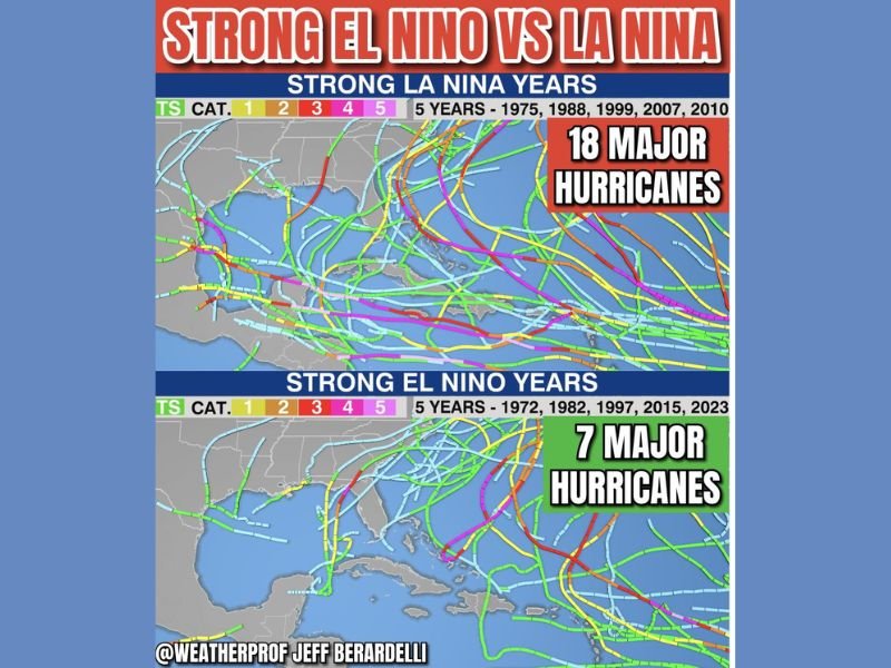
Strong La Niña Years Produced 18 Major Hurricanes Across Five Seasons
Looking at the five strongest La Niña years on record — 1975, 1988, 1999, 2007, and 2010 — the Atlantic basin produced a combined 18 major hurricanes reaching Category 3 strength or higher. The storm track maps from these years show dense and widespread activity across the Gulf, Caribbean, and Atlantic, with numerous storms reaching major hurricane intensity and threatening landfall across a broad geographic footprint. La Niña years are consistently associated with reduced wind shear across the Atlantic, allowing storms to develop, intensify, and sustain themselves far more effectively.
Strong El Niño Years Saw Only 7 Major Hurricanes Across the Same Period
By contrast, the five strongest El Niño years — 1972, 1982, 1997, 2015, and 2023 — produced a combined total of just 7 major hurricanes across the Atlantic basin. The storm track maps from these years show significantly reduced activity, with fewer storms reaching major intensity and a notably quieter Gulf and Caribbean corridor. The dramatic reduction from 18 to 7 major hurricanes represents more than a 60% drop in significant storm production, underscoring just how powerfully El Niño can suppress Atlantic hurricane activity.
Why El Niño Suppresses Atlantic Hurricane Activity
The mechanism behind this suppression lies in the major warming of the East Pacific Ocean during El Niño events. That Pacific warmth generates increased wind shear across the Atlantic side of the basin, which disrupts the organized convection that hurricanes need to develop and intensify. The Gulf and Caribbean, overpowered by their relatively warmer Pacific neighbor, experience stable air conditions that limit storm formation and prevent existing systems from reaching major hurricane strength throughout the season.
One Storm Is All It Takes Regardless of Season Outlook
Despite the historically favorable outlook tied to El Niño, forecasters are clear that no season should be taken lightly. Odds strongly favor a relatively quieter season, but a single landfalling major hurricane is capable of causing catastrophic damage regardless of overall seasonal activity levels. Residents across Florida, the Gulf Coast, and Caribbean should remain prepared and maintain readiness throughout the full hurricane season. Stay with NapervilleLocal.com for the latest weather updates and local forecast coverage.

I’ve lived in Naperville long enough to see how quickly our community changes — from new developments downtown to sudden shifts in our Midwest weather. Reporting on Naperville news and daily forecasts gives me the chance to keep neighbors informed about what really matters. My goal is simple: deliver clear, timely updates so you always know what’s happening in our city and what to expect from the skies above.