
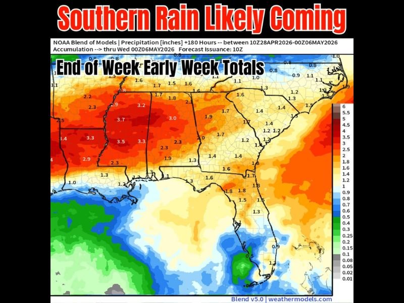
Heavy Rain Totals of 2 to 4 Inches Likely Across the South Including Mississippi, Alabama, and Tennessee Through Early Next Week With Lingering Frontal Pattern in Place
SOUTH — A lingering frontal boundary across the South is setting up a prolonged rainfall pattern that will keep rain chances elevated from the end of this week through early next week across a broad region. The NOAA blend of models shows accumulated precipitation totals between April 28 and May 6, 2026, with the heaviest totals of 3 to 4 inches or more concentrated across Mississippi, Alabama, and portions of Tennessee and Arkansas.
The overall pattern is established with some uncertainty remaining on exact totals, but the general idea of a wet end of week into early next week is well supported across the region.
Heaviest Rainfall Totals of 3 to 4 Inches Focused Across Mississippi and Alabama
The core of the heaviest rainfall accumulation through the end of April and into early May is centered across Mississippi and Alabama, where model totals reach 3.2 to 3.7 inches across the heaviest zones. Portions of western Alabama and central Mississippi are showing the most significant accumulation potential, with values approaching and exceeding 3.5 inches in the highest zones on the precipitation map.
These totals represent a meaningful and sustained rainfall event for a region that has been dealing with drought conditions and elevated wildfire risk in recent weeks. The prolonged nature of the rainfall pattern, driven by a lingering frontal boundary, increases the probability of significant accumulations across the core of the affected area.
Tennessee, Arkansas, and Georgia Seeing 2 to 3 Inch Totals Through the Period
Surrounding the heaviest core, a broad swath of the South including Tennessee, Arkansas, and northern Georgia is forecast to see rainfall accumulations in the 2 to 3 inch range through the same April 28 to May 6 window. Communities across these states will benefit from the extended rainfall pattern but with somewhat lower totals than the Mississippi and Alabama core zone.
The Carolinas and Virginia are forecast to see lighter totals in the 1 to 2 inch range on the eastern fringe of the system, while the Florida peninsula may see a few storms developing off the Gulf later in the period around Sunday. Rainfall coverage will be uneven across all areas depending on how the frontal boundary shifts through the period.
Rain Chances Elevated Into Early Next Week as Frontal Boundary Lingers
The lingering frontal line is expected to keep rain chances elevated not just through this week but continuing into early next week for many communities across the South. This extended pattern means residents should not expect a quick end to the wet conditions once initial rainfall moves through their area.
Exact totals remain uncertain given the extended forecast range and the tendency for frontal boundaries to shift north or south depending on atmospheric dynamics through the period. The overall pattern and general idea of a significantly wetter than normal end of April and early May is well established across the region. Stay with NapervilleLocal.com for the latest weather updates and local forecast coverage.

Naperville is a community with stories that deserve to be told — both the serious ones about safety and justice, and the lighter ones that capture our culture and daily life. I focus on covering crime reports and court updates while also highlighting the traditions, events, and social trends that shape who we are. Through my reporting, I want to give readers a fuller picture of Naperville — the challenges we face and the character that keeps our city strong.