
Torrential Rain, 40 MPH Winds, Frequent Lightning, and Small Hail Moving Into South Carolina Including Greenville, Clemson, and Anderson With Visibility Dropping Fast Now
UPSTATE SOUTH CAROLINA — A strong and rapidly moving storm is pushing into the Upstate South Carolina region right now, packing 40 mile per hour winds, torrential rain, frequent lightning, and the potential for small hail mixed in with the heaviest precipitation. Greenville, Clemson, Anderson, Mauldin, and surrounding communities are directly in the path of this storm as it tracks through the area. Visibility is expected to drop quickly as the heaviest rain moves through, and anyone currently out on the roads should give themselves extra time and reduce speeds significantly.
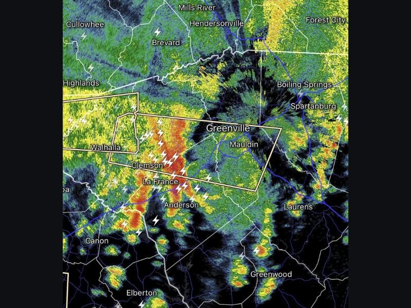
Torrential Rain and 40 MPH Winds Moving Through the Greenville Corridor Now
The storm currently pushing into the Greenville area is producing intense rainfall rates capable of causing rapid visibility reductions across roadways and low-lying areas. Wind gusts reaching 40 miles per hour accompanying the heaviest rain will make driving conditions particularly hazardous, with the potential for downed branches and debris on roadways throughout the affected corridor.
Radar imagery shows the most intense storm cores moving through the Clemson, La France, and Anderson area and tracking toward Greenville and Mauldin. The storm warning box visible on radar covers a defined corridor from Walhalla through Clemson and La France into the Greenville and Mauldin area, indicating the highest intensity precipitation is focused along this track.
Frequent Lightning Making This Storm Dangerous for Anyone Outdoors
Frequent lightning is one of the most significant hazards with this storm system moving through Upstate South Carolina, with lightning bolt signatures visible across a wide area from Highlands and Cullowhee through Brevard, Clemson, Anderson, and extending toward Spartanburg and Laurens. Anyone outdoors in the affected region should seek immediate shelter indoors or in a hard-topped vehicle until the storm passes completely.
Lightning from this storm is not isolated to the heaviest rain core and extends well ahead of and behind the most intense precipitation. Schools, parks, athletic fields, and outdoor venues across the entire Upstate corridor should suspend all outdoor activities immediately until the storm clears the area.
Small Hail Possible With Heaviest Storm Cores Across the Affected Area
Small hail is possible mixed in with the torrential rain as the most intense storm cores move through the Greenville and Anderson corridor. While small hail does not carry the destructive potential of larger stones, it can contribute to rapidly deteriorating road conditions and reduced visibility when accumulating on roadway surfaces during heavy rain events.
The storm is expected to move through the area relatively quickly given its forward speed, but conditions will remain dangerous during its passage. Residents in Greenville, Clemson, Anderson, Mauldin, and surrounding communities should stay indoors until radar confirms the heaviest activity has cleared their location. Stay with NapervilleLocal.com for the latest weather updates and local forecast coverage.

Naperville is a community with stories that deserve to be told — both the serious ones about safety and justice, and the lighter ones that capture our culture and daily life. I focus on covering crime reports and court updates while also highlighting the traditions, events, and social trends that shape who we are. Through my reporting, I want to give readers a fuller picture of Naperville — the challenges we face and the character that keeps our city strong.