
Significant Spring Storm With Snow, Rain, and Severe Thunderstorms Targeting Colorado Including Denver, Colorado Springs, and Pueblo From Wednesday Night Through Friday
COLORADO AND FRONT RANGE — A significant and complex spring storm system is taking shape for Colorado and the Front Range, with impacts expected to begin Wednesday afternoon and intensify through Wednesday night, Thursday, and linger into Friday.
A cold front dropping in from the north will link up with a storm system emerging from the Desert Southwest, creating a multi-hazard event that will affect elevations from the mountains down through the Denver metro and Front Range communities. Exact storm track, timing, temperatures, and duration all remain in question, making this a forecast that will continue to evolve through Wednesday.
Isolated Showers and Thunderstorms Possible Today Before the Main System Arrives
A weak front sliding through today, Tuesday April 28, is keeping scattered to widely scattered showers across the region, with snow levels starting near 5,500 feet this morning. A few afternoon thunderstorms are possible mainly along and north of Interstate 70 as daytime heating increases through the afternoon hours.
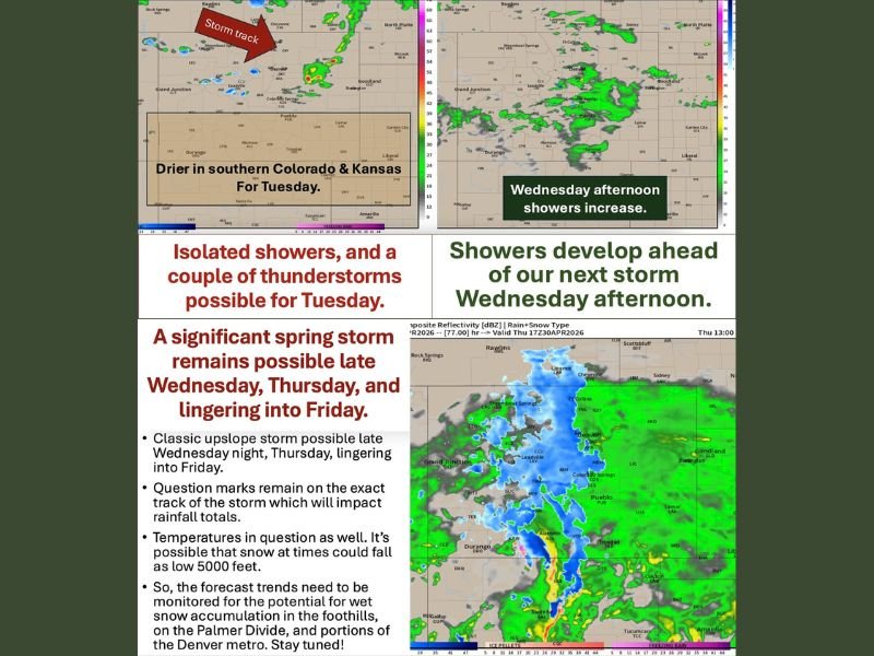
Southern Colorado and southern Kansas are expected to remain drier through Tuesday, with the main precipitation focus staying along and north of the I-70 corridor. Temperatures today are running similar to Monday with no significant severe weather concerns expected before the larger system arrives Wednesday.
Significant Spring Storm Develops Wednesday Night Through Thursday Across the Region
Showers begin developing Wednesday afternoon ahead of the incoming system before precipitation becomes widespread Wednesday night into Thursday and lingers into Friday. The storm has the characteristics of a classic upslope event, with moisture flowing up the Front Range terrain capable of producing substantial precipitation accumulations across the foothills, Palmer Divide, and portions of the Denver metro.
The Palmer Divide and higher west and south Denver metro areas at approximately 6,000 feet and above could see rain mixing with or changing to wet snow as the system deepens. Snow levels remain uncertain and could drop as low as 5,000 feet at times during the height of the storm, making wet snow accumulations possible across the foothills and elevated terrain.
Snow Possible in Foothills and Palmer Divide While Severe Storms Threaten Southeast Colorado
Mountains and higher foothills are expected to see snow from this system while lower elevations below 5,000 feet will primarily see rain across the Denver metro and Front Range communities. The Palmer Divide and higher south and west Denver metro areas face the greatest uncertainty regarding rain versus wet snow accumulations depending on how storm track and temperatures evolve.
Far southern and southeast Colorado face a different threat entirely, where the potential for strong to severe thunderstorms exists on the southern edge of the system. Exact rainfall totals and snow accumulation amounts will be refined as track and temperature details become clearer heading into Wednesday. Stay with NapervilleLocal.com for the latest weather updates and local forecast coverage.

Naperville is a community with stories that deserve to be told — both the serious ones about safety and justice, and the lighter ones that capture our culture and daily life. I focus on covering crime reports and court updates while also highlighting the traditions, events, and social trends that shape who we are. Through my reporting, I want to give readers a fuller picture of Naperville — the challenges we face and the character that keeps our city strong.