
May Is Prime Tornado Month Across the Plains and Midwest Including Oklahoma City, Wichita, Kansas City, and Chicago as Tornado Alley Wakes Up This Month
PLAINS AND MIDWEST — May is historically the most active and dangerous month for tornadoes across the United States, and the average tornado risk map for the month shows just how large a portion of the country falls within the threat zone.
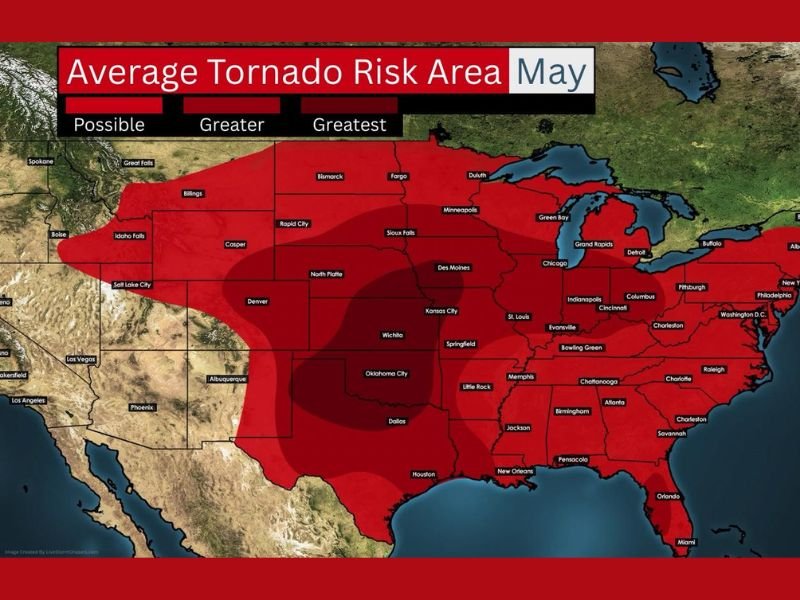
The greatest tornado risk during May is centered across the Southern and Central Plains, covering Oklahoma City, Wichita, Dallas, Kansas City, and St. Louis, while a broader greater risk zone extends across the entire Midwest including Chicago, Indianapolis, Memphis, and Little Rock. Tornadoes are possible across an enormous footprint stretching from the Gulf Coast all the way through the northern Plains and into portions of the Mid-Atlantic and Southeast.
Southern and Central Plains Face the Greatest Average Tornado Risk During May
The darkest red shading on the average May tornado risk map covers the core of Tornado Alley across Oklahoma, Kansas, northern Texas, and Missouri, where the greatest concentration of tornado activity historically occurs during the month. Communities including Oklahoma City, Wichita, Dallas, Kansas City, and Springfield sit within the highest-risk corridor where all of the ingredients for violent tornado production come together most reliably during May.
The jet stream lifting northward during May creates the critical overlap between moisture, instability, and wind shear that fuels the most dangerous severe weather setups of the entire year. When these ingredients align with surface boundaries across the Plains, the result can be some of the most prolific tornado outbreaks on record.
Greater Risk Zone Covers Chicago, Indianapolis, St. Louis, and the Entire Midwest
Surrounding the greatest risk core, a broad greater risk zone extends across a massive footprint covering the entire Midwest from the Dakotas and Minnesota southward through Illinois, Indiana, Ohio, and into the Mid-South. Major population centers including Chicago, Indianapolis, Columbus, Cincinnati, Memphis, and Little Rock all fall within this elevated average tornado risk zone for the month of May.
Boundary-driven severe weather days become increasingly common during May, when leftover outflow boundaries from previous storms can interact with heat and humidity to quickly transform a seemingly quiet afternoon into a dangerous severe weather situation. These boundary-driven events can occur with less lead time than classic supercell setups and can affect communities well outside the traditional Plains tornado corridor.
Tornado Risk Extends From Gulf Coast Through Northern Plains and Into the Southeast
The broader possible risk zone on the May average map covers an enormous area stretching from Houston and New Orleans northward through the entire central United States and eastward across the Southeast through Atlanta, Charlotte, and Washington D.C. This expansive coverage reflects the reality that May tornadoes are not limited to Tornado Alley and can occur across a wide range of environments when conditions align.
Residents across every state within the average May tornado risk footprint should ensure their severe weather preparedness is updated and current as the month begins. Having multiple ways to receive tornado warnings, knowing the nearest sturdy shelter, and staying informed on daily forecast updates are the most important steps anyone can take during the most active tornado month of the year. Stay with NapervilleLocal.com for the latest weather updates and local forecast coverage.

I’ve lived in Naperville long enough to see how quickly our community changes — from new developments downtown to sudden shifts in our Midwest weather. Reporting on Naperville news and daily forecasts gives me the chance to keep neighbors informed about what really matters. My goal is simple: deliver clear, timely updates so you always know what’s happening in our city and what to expect from the skies above.