
Rare May Snow Mix and Heavy Rain Targeting Iowa and Northern Missouri Including Des Moines and Omaha Early Friday Morning as Intensifying Storm System Arrives Tonight
IOWA AND NORTHERN MISSOURI — What started as a small chance of snow mixing with rain has grown into a much larger and more noteworthy possibility for portions of Iowa and the surrounding region as May begins. A small storm system over Iowa is expected to intensify through tonight, bringing moderate to heavy showers late tonight into early Friday morning, May 1, 2026.
If precipitation rates become heavy enough, snowflakes mixing with rain are possible across the best chance zone, marking what would be a rare May snow event for the region with the last May snowfall reaching the ground dating all the way back to 1989.
Intensifying Storm System Brings Moderate to Heavy Rain Late Tonight Into Friday Morning
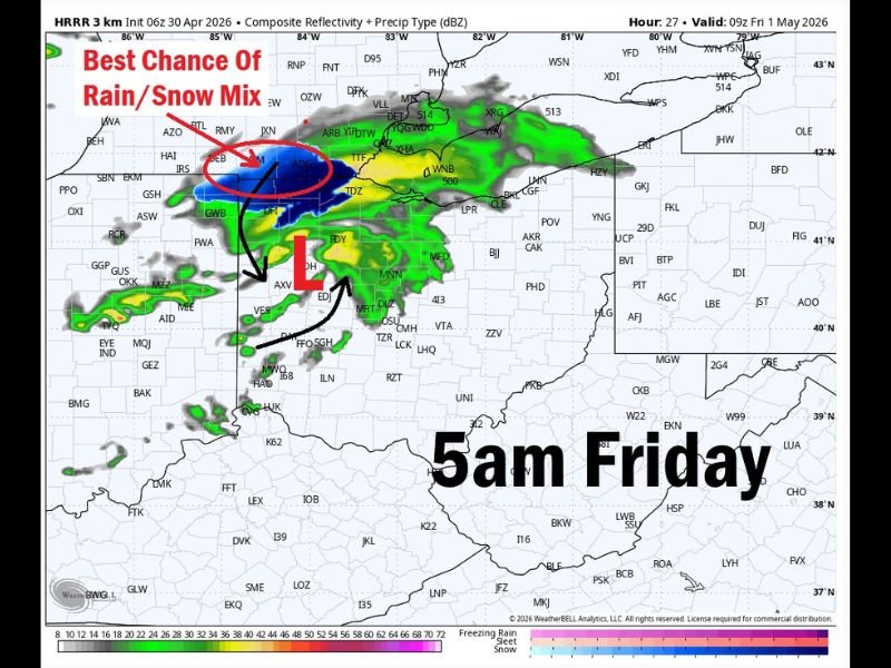
A storm system currently over Iowa is forecast to intensify through tonight, spreading moderate to heavy shower activity across portions of the region during the late night and early morning hours. The HRRR model valid at 5 AM Friday shows a well-defined low pressure center with an associated precipitation shield covering a broad area, with the heaviest cores concentrated in the best chance zone for rain and snow mix across northern and central portions of the region.
The rate of precipitation will be the critical factor in determining how significant tonight’s rainfall event becomes. Heavy precipitation rates increase evaporative cooling in the lower atmosphere, which is the mechanism that could allow snowflakes to reach the ground despite above-freezing air temperatures and a ground temperature of approximately 60 degrees.
Snow Mixing With Rain Possible if Precipitation Rates Become Heavy Enough
The chance of snowflakes mixing with rain tonight hinges entirely on whether precipitation becomes heavy enough to trigger sufficient evaporative and melting-driven cooling in the lowest levels of the atmosphere. When precipitation is heavy, evaporation cools the air rapidly as rain falls into drier air below, and the melting of snowflakes at low levels also contributes additional cooling that can allow snow to reach the ground even when temperatures are above freezing.
A snow burst scenario is possible if the heaviest precipitation rates materialize, though air temperatures hovering above freezing and the warm ground temperature of around 60 degrees make it highly unlikely that any snow would accumulate. The event would be primarily a visual novelty rather than an impactful accumulating snow scenario for the region.
Rare May Snow Event Would Be First Since 2020 With Accumulating Snow Not Seen Since 1989
Any snowflakes reaching the ground tonight would mark a rare and historically notable May snow occurrence for the region. The last time snow fell to the ground during the month of May in this area was during 2020, and the last time May snow actually stuck to the ground and accumulated was in 1989, making any accumulating snow scenario an extraordinarily rare meteorological event.
Residents across Iowa and surrounding areas should not expect significant snowfall impacts from tonight’s event given the warm ground temperatures and above-freezing air. However, the possibility of seeing snowflakes in early May is a remarkable enough occurrence that weather observers across the region will be watching tonight’s precipitation closely. Stay with NapervilleLocal.com for the latest weather updates and local forecast coverage.

I’ve lived in Naperville long enough to see how quickly our community changes — from new developments downtown to sudden shifts in our Midwest weather. Reporting on Naperville news and daily forecasts gives me the chance to keep neighbors informed about what really matters. My goal is simple: deliver clear, timely updates so you always know what’s happening in our city and what to expect from the skies above.