
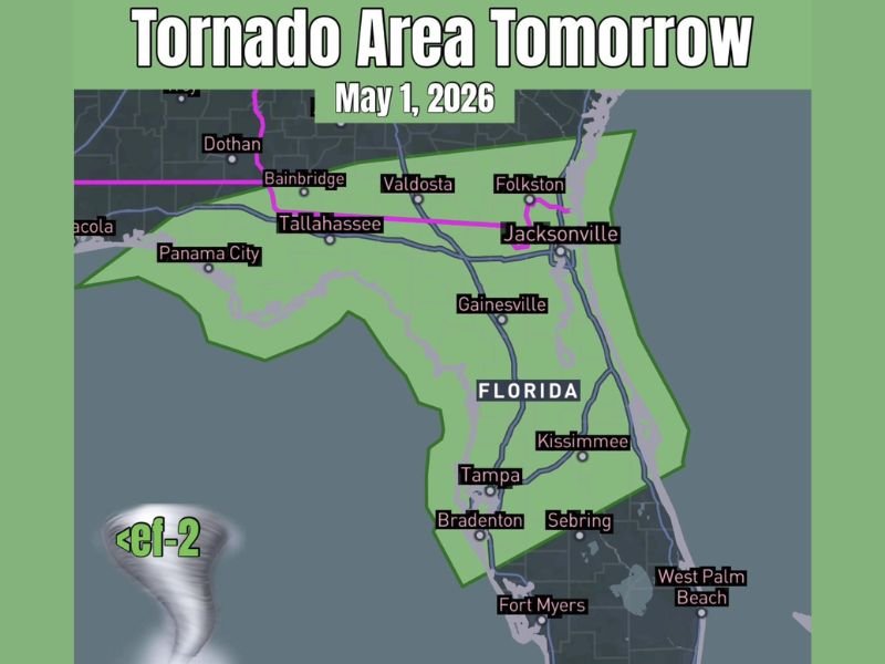
Tornado Potential and Damaging Winds Targeting Florida Including Jacksonville, Tallahassee, Tampa and West Palm Beach Friday Into Friday Afternoon
FLORIDA — A line of storms carrying embedded circulations and tornado potential will sweep across Florida on Friday, May 1, 2026, affecting a broad zone stretching from the Panhandle through central Florida. The threat is not expected to be widespread or significant, but enough potential exists across the green zone to warrant awareness. Tornadoes, if they occur, are expected to remain below EF-2 intensity.
Morning Storm Line Brings First Round of Tornado Threat Across Northern Florida
A line of storms will push across northern Florida during the morning hours, potentially containing one or more embedded circulations. Cities including Tallahassee, Jacksonville, Folkston, Valdosta, and the Panhandle communities of Panama City and Pensacola fall within the primary impact zone for this first round.
The main hazards with this line include damaging winds and a random, isolated tornado chance. Timing favors the morning, so residents in the northern portions of the state should be weather-aware before midday.
Central Florida Faces Later Arrival With Similar Storm Mode
Further south across central Florida, including areas near Gainesville, Tampa, Kissimmee, Bradenton, Sebring, and West Palm Beach, the storm line will arrive later in the day. The same storm mode and tornado potential applies, though timing shifts into the afternoon and evening hours.
The threat here mirrors the north — not significant or widespread, but enough embedded circulation potential to track carefully. Residents in central Florida have additional time to prepare before storms arrive.
Tornado Threat Capped Below EF-2 Across the Entire Risk Zone
The source data indicates that any tornadoes that develop will remain below EF-2 strength. While this limits the ceiling on intensity, even sub-EF-2 tornadoes can cause localized structural damage, downed trees, and hazardous conditions for those caught outdoors.
Anyone living or traveling within the green zone shown on the risk map should have a weather safety plan in place and access to alerts throughout Friday. Stay with NapervilleLocal.com for the latest weather updates and local forecast coverage.

I’ve lived in Naperville long enough to see how quickly our community changes — from new developments downtown to sudden shifts in our Midwest weather. Reporting on Naperville news and daily forecasts gives me the chance to keep neighbors informed about what really matters. My goal is simple: deliver clear, timely updates so you always know what’s happening in our city and what to expect from the skies above.