
Flash Flood Warning in Effect Until Noon as Next Round of Severe Thunderstorms Targets Bexar County Including San Antonio and New Braunfels Within 30 to 45 Minutes
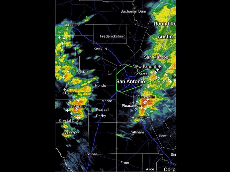
BEXAR COUNTY, TEXAS — A new and dangerous round of showers and thunderstorms is moving east and is expected to reach Bexar County within 30 to 45 minutes of a 10:35 AM observation on Friday, May 1, 2026. A Flash Flood Warning is already in effect for the area until noon, signaling that flooding conditions are either occurring or imminent across San Antonio and surrounding communities. Radar at 10:34 AM is showing intense red and orange cores moving directly toward the greater San Antonio metro zone.
Intense Storm Cores Moving East and Arriving in Bexar County Within Minutes
Radar is tracking a well-organized and intense line of showers and thunderstorms approaching from the west, with the heaviest cores currently located near Junction, Utopia, Uvalde, Batesville, and Crystal City. The storm line is moving east at a pace that places its arrival in Bexar County, including San Antonio, Schertz, and New Braunfels, within the 30 to 45 minute window from the time of the 10:35 AM update.
Lightning is widespread and frequent across the entire approaching line, with multiple embedded thunderstorm cells showing significant electrical activity. Residents across San Antonio and Bexar County should be indoors and away from windows well ahead of storm arrival.
Flash Flood Warning Covers San Antonio Metro Until Noon Friday
A Flash Flood Warning is in effect for Bexar County until noon on Friday, indicating that life-threatening flash flooding is possible or already developing across the warned area. The combination of an already saturated environment and another round of heavy rainfall arriving imminently creates dangerous conditions for roads, low-lying areas, and flood-prone neighborhoods throughout the San Antonio metro.
Areas including Pleasanton, Floresville, Campbellton, and Schertz are also tracking intense storm activity on radar with active lightning signatures. Residents in these communities should treat the Flash Flood Warning with the same urgency as those directly inside the San Antonio city limits.
Storm Activity Also Ongoing Across Austin, San Marcos and Eastern Corridor
To the east and northeast of San Antonio, significant storm activity is already ongoing across the Austin metro, Round Rock, San Marcos, and New Braunfels. Radar is showing heavy green, yellow, and orange returns across this entire eastern corridor, indicating widespread rainfall and embedded thunderstorm activity that has been ongoing ahead of the approaching western line.
Anyone with travel plans across the San Antonio to Austin corridor on Friday morning should delay all non-essential trips until conditions improve and the Flash Flood Warning expires. Stay with NapervilleLocal.com for the latest weather updates and local forecast coverage.

I’ve lived in Naperville long enough to see how quickly our community changes — from new developments downtown to sudden shifts in our Midwest weather. Reporting on Naperville news and daily forecasts gives me the chance to keep neighbors informed about what really matters. My goal is simple: deliver clear, timely updates so you always know what’s happening in our city and what to expect from the skies above.