
Heavy Rain Missing Most of the Upstate as Low Pressure Tracks Further South Leaving Charlotte, Asheville, and Greenville With Only Drizzle and Spotty Showers Through Midday
CAROLINAS — An overnight shift in the low pressure track has pushed the heaviest rain further south than originally expected, leaving most of the Upstate and western Carolinas with only drizzle and spotty showers through midday Saturday. The top edge of the rain line has dropped to the southern Upstate rather than I-85, creating a sharp divide between counties seeing pouring rain and those catching only light and disappointing moisture. Temperatures will remain chilly near 60 degrees throughout the day with more rain chances returning by Wednesday and Thursday.
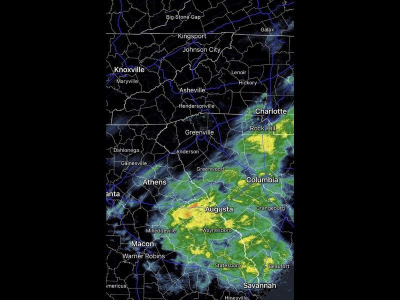
Low Pressure Tracking Further South Pulls Heavy Rain Away From Most of the Upstate
The overnight southward shift of the low pressure system has been the defining change to Saturday’s forecast, separating communities by just a few miles in terms of rainfall outcome. Areas along and south of the southern Upstate boundary are seeing the heaviest and most meaningful rainfall, while communities to the north are left with frustratingly light drizzle and on-and-off spotty showers through the midday hours.
Charlotte, Asheville, Greenville, Anderson, and Hendersonville fall on the drier side of this shifted boundary, missing out on the heavier rainfall totals that had been anticipated earlier in the forecast cycle.
Augusta, Columbia, and Waynesboro Receiving the Heaviest Rain Saturday Morning
Radar is showing the most intense returns concentrated across Augusta, Waynesboro, Columbia, and Orangeburg, where the heaviest cores of orange and red are clearly positioned well south of the Upstate boundary. These southern communities are receiving the soaking and meaningful rainfall that most of the Carolinas were originally expecting.
Areas including Savannah, Statesboro, Beaufort, and Rock Hill are also tracking significant green returns, confirming that the bulk of Saturday’s beneficial moisture is staying firmly south of the original forecast zone.
Chilly 60 Degree Temperatures Persist Through Saturday With Next Rain Chance Wednesday
Temperatures across the entire region will hold in the chilly range near 60 degrees through Saturday regardless of rainfall totals. The next meaningful opportunity for rain returns by Wednesday and Thursday as another system approaches the region. Stay with NapervilleLocal.com for the latest weather updates and local forecast coverage.

I’ve lived in Naperville long enough to see how quickly our community changes — from new developments downtown to sudden shifts in our Midwest weather. Reporting on Naperville news and daily forecasts gives me the chance to keep neighbors informed about what really matters. My goal is simple: deliver clear, timely updates so you always know what’s happening in our city and what to expect from the skies above.