
Damaging Hail, Winds and Tornadoes Targeting Oklahoma, Texas and Arkansas Tuesday May 5 Shifting Into Texas, Louisiana and Houston Wednesday May 6 as Severe Risk Returns
SOUTHERN PLAINS — Severe weather is returning to the Southern Plains next week after a quiet weekend and Monday break, with a dangerous and highly sheared environment setting up ahead of a dryline and cold front. Oklahoma, Texas, and Arkansas face the primary severe weather risk on Tuesday, May 5, with the threat then shifting south into eastern Texas, Louisiana, and the Houston corridor on Wednesday, May 6. Damaging hail and winds are the main hazards across both days, but tornadoes cannot be ruled out across either risk zone.
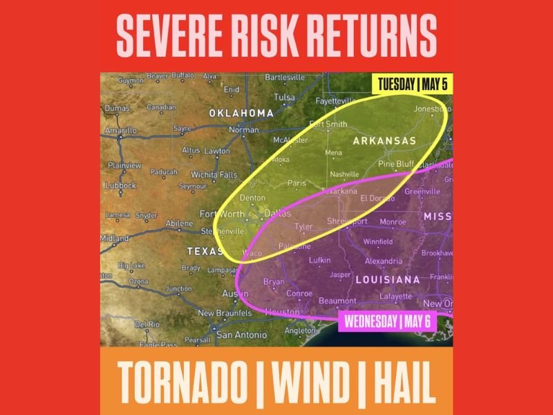
Damaging Hail, Winds and Tornado Threat Cover Oklahoma, Texas and Arkansas Tuesday
The Tuesday, May 5 risk zone covers a broad yellow-outlined area stretching from eastern Oklahoma through north and central Texas and into Arkansas, including Fort Worth, Dallas, Denton, Fort Smith, Texarkana, and Jonesboro. An unstable and highly sheared atmosphere setting up ahead of the approaching dryline and cold front will provide all the ingredients necessary for organized severe storm development across this zone.
Damaging hail and destructive winds represent the primary hazards on Tuesday, but the environment will also support tornado development. Residents across the entire yellow zone should have weather alerts activated and a safety plan ready well ahead of Tuesday afternoon and evening.
Severe Threat Shifts South Into Houston, Louisiana and East Texas Wednesday May 6
The Wednesday, May 6 risk zone shifts southward into a pink-outlined area covering eastern Texas including Tyler, Lufkin, Beaumont, and Houston, extending east through Louisiana toward Lafayette, Alexandria, and New Orleans. The same hazard combination of tornadoes, damaging winds, and large hail remains in play as the system pushes through this southern corridor throughout Wednesday.
The Houston metro and surrounding communities face a particularly significant exposure given the population density within the Wednesday risk zone. All residents from east Texas through Louisiana should monitor forecast updates closely through the early part of next week.
Quiet Weekend and Monday Before Severe Pattern Reloads Midweek Across the Region
The Southern Plains will enjoy a welcome break from severe weather through the weekend and into Monday before the pattern reloads for the Tuesday and Wednesday threat window. Residents should use this quiet period to review preparedness plans and ensure all alert systems are active ahead of the midweek severe weather return. Stay with NapervilleLocal.com for the latest weather updates and local forecast coverage.

I’ve lived in Naperville long enough to see how quickly our community changes — from new developments downtown to sudden shifts in our Midwest weather. Reporting on Naperville news and daily forecasts gives me the chance to keep neighbors informed about what really matters. My goal is simple: deliver clear, timely updates so you always know what’s happening in our city and what to expect from the skies above.