
Heavy Rain Drenching Active Wildfires Across Southeast Georgia Including Waycross, Valdosta, and Brunswick This Morning Bringing Critical Relief to Worst Drought Areas in the State
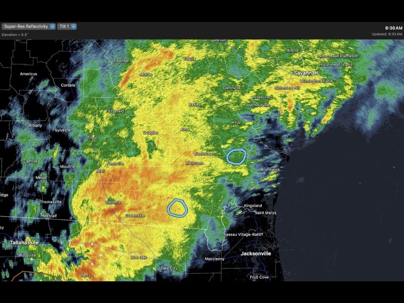
SOUTHEAST GEORGIA — Heavy rain is moving directly over active wildfire locations across Southeast Georgia on Saturday morning, May 2, 2026, delivering critically needed moisture to a region battling both uncontrolled fires and the worst drought conditions in the state. Radar at 8:30 AM is showing intense returns blanketing the entire southeast corner of Georgia from Valdosta through Brunswick and the coastal zone. This is exactly the rainfall the region has been desperately needing.
Heavy Rain Falling Directly Over Two Active Wildfire Zones Saturday Morning
Two active wildfire locations are currently receiving direct heavy rainfall coverage, with one fire zone near Blackshear and Brunswick and a second near Statenville and Valdosta. Both areas are sitting under the heaviest portion of the rain shield as of the 8:33 AM radar update.
Sustained heavy rainfall over these zones has the potential to dramatically reduce fire behavior, lower spread risk, and provide significant assistance to ground crews who have been battling blazes fueled by prolonged drought conditions across the region.
Rain Shield Stretches From Valdosta Through Savannah Covering the Entire Southeast Corner
The rain coverage extends across a massive corridor of Southeast Georgia, reaching from Valdosta and Tifton through Douglas, Waycross, Jesup, and Baxley toward Savannah and the coast. Communities including Nashville, Adel, Alma, Glennville, and Hinesville are all sitting under significant rainfall at this hour.
The most intense radar cores are concentrated across the central and southern portions of the coverage area, where orange and red returns indicate the heaviest rainfall rates moving through the region.
Worst Drought in Georgia Finally Receiving Meaningful and Beneficial Rainfall
Southeast Georgia has been enduring the worst drought conditions in the entire state heading into this weekend, making Saturday morning’s heavy rain arrival both timely and critically important. The combination of active wildfires and severe drought in the same zone created an extraordinarily dangerous environment that this rain is now beginning to address.
Residents should welcome the rainfall while understanding that a single event may not fully resolve the long-term drought deficit that has built up across Southeast Georgia over recent months. Stay with NapervilleLocal.com for the latest weather updates and local forecast coverage.

I’ve lived in Naperville long enough to see how quickly our community changes — from new developments downtown to sudden shifts in our Midwest weather. Reporting on Naperville news and daily forecasts gives me the chance to keep neighbors informed about what really matters. My goal is simple: deliver clear, timely updates so you always know what’s happening in our city and what to expect from the skies above.