
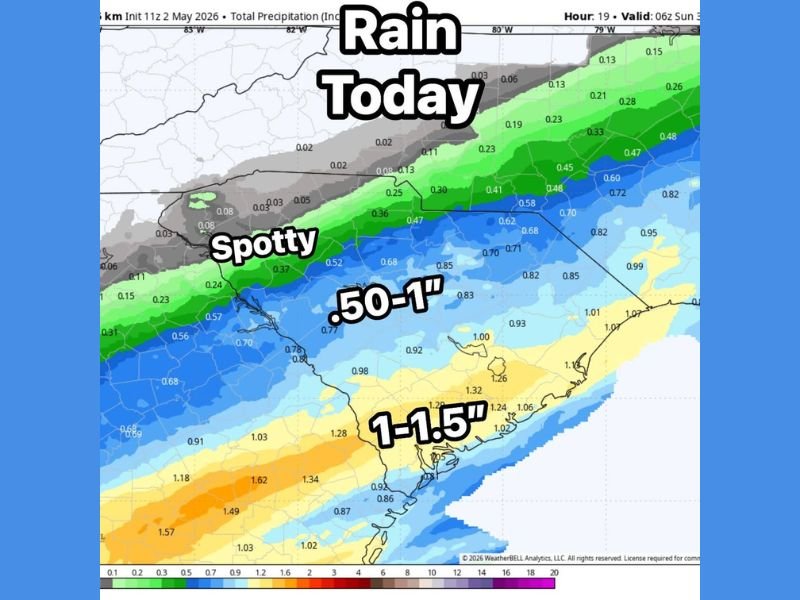
Sharp Rain Gradient Delivers 1 to 1.5 Inches Along the Coast While Counties Just North See Spotty Totals as Low Track Creates Dramatic Cutoff Across the Mid-Atlantic Saturday
MID-ATLANTIC — A slight jog in the low pressure track is creating a dramatic and sharp precipitation cutoff across the Mid-Atlantic region on Saturday, May 2, 2026, with some areas directly under the track picking up well over an inch of rain while counties just a couple of miles north receive hardly anything. Forecast modeling valid through 6 AM Sunday is showing a well-defined gradient running from spotty and minimal totals in the north to 1 to 1.5 inch accumulations along the southern coastal zones. The difference of just one county can mean the difference between a soggy soaking day and a nearly dry one.
Coastal and Southern Zones Picking Up 1 to 1.5 Inches Under the Low Track
Areas directly under and south of the low pressure track are seeing the heaviest rainfall totals of the event, with accumulations in the 1 to 1.5 inch range across the southern coastal corridor. Precipitation totals exceeding 1.0 inch are widespread through this zone, with some of the highest values reaching 1.57 to 1.62 inches in the southernmost portions of the coverage area.
The 0.50 to 1.0 inch zone sits just north of the heaviest corridor, still delivering meaningful and beneficial rainfall across a broad mid-section of the region. Communities in this middle band are receiving a solid soaking rain even if they fall short of the highest totals found further south.
Sharp Cutoff Leaves Northern Counties With Spotty and Minimal Rainfall Saturday
Just a couple of counties north of the heaviest rain band, totals drop off sharply to spotty and largely insignificant amounts in the 0.02 to 0.13 inch range. This dramatic cutoff is entirely driven by the slight southward jog in the low pressure track overnight, which pulled the main moisture corridor away from northern communities that were originally expecting more meaningful rainfall.
The grey zone across the far northern portions of the map is receiving essentially nothing, highlighting just how sensitive today’s rainfall distribution is to the exact track of the low pressure system.
Slight Low Track Shift Proves Decisive in Determining Who Gets Soaked Saturday
The core lesson from Saturday’s setup is how dramatically a minor shift in low pressure track can redistribute rainfall outcomes across short distances. Areas fortunate enough to sit under the track are receiving a genuine soaking, while neighbors just to the north are left largely dry by a margin of mere miles. Stay with NapervilleLocal.com for the latest weather updates and local forecast coverage.

I’ve lived in Naperville long enough to see how quickly our community changes — from new developments downtown to sudden shifts in our Midwest weather. Reporting on Naperville news and daily forecasts gives me the chance to keep neighbors informed about what really matters. My goal is simple: deliver clear, timely updates so you always know what’s happening in our city and what to expect from the skies above.