
Light to Moderate Rain Spreading Across South Carolina Including Florence, Sumter, Charleston and Myrtle Beach Over the Next Hour Saturday Morning
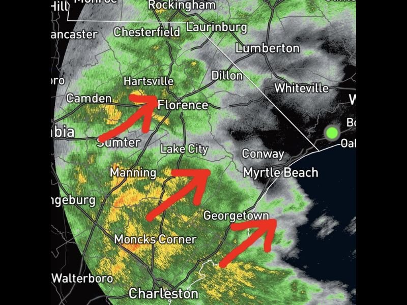
SOUTH CAROLINA — A large area of light to moderate rain is spreading across South Carolina as of the 9:15 AM radar update on Saturday, May 2, 2026, with coverage expected to expand significantly over the next hour. Radar is showing the most intense returns concentrated across the Florence, Sumter, Manning, Moncks Corner, and Georgetown corridors, with the rain shield pushing northeast toward the coast. Charleston and the surrounding Lowcountry are already tracking rainfall, and the entire region from the Midlands through the Grand Strand is coming under increasing coverage through the late morning hours.
Heaviest Rain Cores Tracking Northeast Across Florence, Sumter and Manning
The most intense radar returns at 9:15 AM are located across the Sumter, Manning, and Florence corridor, where orange and yellow cores indicate the heaviest rainfall rates within the broader light to moderate rain shield. Red arrows on radar imagery point northeast, confirming the storm motion pushing the heaviest activity toward Florence, Lake City, and the broader Pee Dee region.
Communities including Camden, Hartsville, and Orangeburg are also sitting inside the active rain zone as the system continues its northeastward progression through the morning hours. Rainfall from these heavier cores is capable of producing brief periods of reduced visibility and ponding on roadways.
Georgetown, Moncks Corner and Charleston Tracking Active Rainfall Saturday Morning
Further south and southeast, Georgetown, Moncks Corner, and Charleston are all sitting under active radar returns as the rain shield extends through the Lowcountry. The northeastern motion of the system is directing rainfall toward the coast, bringing the Conway and Myrtle Beach areas into the expanding coverage zone over the next hour.
Areas including Lumberton, Laurinburg, Whiteville, and Dillon are positioned in the path of the advancing rain shield and can expect increasing coverage through the late morning period as the system pushes into the northeastern portions of the Carolinas.
Large Rain Shield Expected to Expand Coverage Significantly Over the Next Hour
The overall rain area is forecast to continue spreading and expanding through the 10 AM to 11 AM window, bringing light to moderate rainfall to communities currently sitting on the dry edge of the shield. Residents across the entire South Carolina Midlands and coastal zones should expect wet conditions to persist through the late morning hours Saturday. Stay with NapervilleLocal.com for the latest weather updates and local forecast coverage.

I’ve lived in Naperville long enough to see how quickly our community changes — from new developments downtown to sudden shifts in our Midwest weather. Reporting on Naperville news and daily forecasts gives me the chance to keep neighbors informed about what really matters. My goal is simple: deliver clear, timely updates so you always know what’s happening in our city and what to expect from the skies above.