
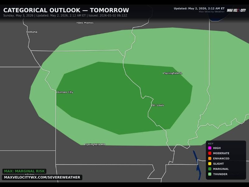
Isolated Supercells With Large Hail and Damaging Winds Possible Across Kansas City, St. Louis and Springfield Illinois Sunday Under Marginal Risk Outlook
MIDWEST — Isolated severe storms are possible across a broad swath of the Midwest on Sunday, May 3, 2026, with Kansas City, St. Louis, and Springfield Illinois all sitting inside a Marginal Risk categorical outlook zone. A couple of supercells carrying large hail and damaging winds represent the primary hazards for the day. Tornado risk is described as very low to zero, keeping the overall threat level manageable but not ignorable for communities across the risk zone.
Isolated Supercells With Large Hail and Damaging Winds Expected Across the Risk Zone
The primary severe weather mode for Sunday is isolated supercell development, with forecasters expecting a couple of discrete storms capable of producing large hail and damaging winds across the Marginal Risk area. The highest confidence threat zone sits across a darker green inner core covering Kansas City through St. Louis and into Springfield Illinois, where supercell potential is most concentrated.
While the overall setup does not support a widespread or prolific severe weather outbreak, individual supercells can still produce significant hail and damaging wind gusts capable of causing localized property damage and creating hazardous conditions for anyone caught outdoors.
Tornado Risk Rated Very Low to Zero Across the Entire Outlook Area Sunday
Forecasters are placing the tornado risk at very low to zero across the entire Sunday risk zone, which is a meaningful distinction from more dangerous setups. The atmospheric environment on Sunday lacks the ingredients needed to support significant tornado development, keeping the threat profile focused squarely on hail and wind rather than tornado potential.
Residents across Kansas City, St. Louis, and Springfield Illinois should remain weather aware but can take some comfort in the low tornado probability attached to this particular Sunday setup.
Marginal Risk Zone Extends Broadly From Omaha Through Springfield Missouri Sunday
The full Marginal Risk and general thunder zone extends broadly from near Omaha and Des Moines in the north through Kansas City, St. Louis, Springfield Illinois, and Springfield Missouri in the south. Communities across this entire zone should monitor afternoon and evening storm development closely and stay connected to weather alerts throughout Sunday. Stay with NapervilleLocal.com for the latest weather updates and local forecast coverage.

I’ve lived in Naperville long enough to see how quickly our community changes — from new developments downtown to sudden shifts in our Midwest weather. Reporting on Naperville news and daily forecasts gives me the chance to keep neighbors informed about what really matters. My goal is simple: deliver clear, timely updates so you always know what’s happening in our city and what to expect from the skies above.