
Large Hail, Damaging Winds and TBD Tornado Risk Return to Central and Northern Indiana Monday May 4 Under Marginal Risk With 15 Percent Severe Probability Corridor
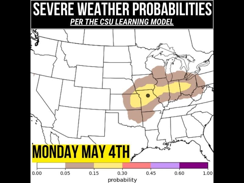
INDIANA — Severe weather probabilities are returning to central and northern Indiana on Monday, May 4, 2026, with the Storm Prediction Center highlighting a low end Marginal Risk across the region. The CSU learning model is painting a slightly more aggressive picture, placing a 15 percent severe weather probability corridor across the same general area covering central and northern Indiana into neighboring states. While this does not look like a widespread or major event, Monday afternoon and evening will need to be watched carefully for isolated instances of large hail and damaging winds.
Marginal Risk and 15 Percent Probability Corridor Cover Central and Northern Indiana Monday
The SPC Marginal Risk designation and the CSU learning model’s 15 percent probability zone are both aligned across central and northern Indiana for Monday, giving forecasters increasing confidence that at least isolated severe weather is possible during the afternoon and evening hours. The CSU model’s yellow core sits directly over the central Indiana region, surrounded by a broader tan probability zone extending into neighboring states.
The agreement between the SPC outlook and the more aggressive CSU model corridor adds credibility to the Monday severe weather signal, even if the overall event ceiling remains at the isolated and non-widespread end of the spectrum.
Large Hail and Damaging Winds Headline the Monday Afternoon and Evening Threat
Large hail and damaging winds are the two primary hazards being monitored for Monday’s severe weather window across central and northern Indiana. These hazards are most likely to materialize during the peak heating hours of Monday afternoon before continuing into the evening as storm activity persists.
The tornado risk for Monday carries a TBD designation, meaning forecasters have not yet ruled it out but cannot confirm it as a defined threat at this stage. Residents should treat the tornado component as a possibility worth monitoring as better forecast details emerge over the next 24 to 48 hours.
Isolated Rather Than Widespread Event Expected Across the Monday Risk Zone
Monday’s setup does not carry the hallmarks of a major or widespread severe weather outbreak across Indiana. The isolated nature of the expected storm activity means not every community in the risk zone will see severe weather, but those that do encounter storms should be prepared for large hail and damaging wind potential through the afternoon and evening. Stay with NapervilleLocal.com for the latest weather updates and local forecast coverage.

I’ve lived in Naperville long enough to see how quickly our community changes — from new developments downtown to sudden shifts in our Midwest weather. Reporting on Naperville news and daily forecasts gives me the chance to keep neighbors informed about what really matters. My goal is simple: deliver clear, timely updates so you always know what’s happening in our city and what to expect from the skies above.