
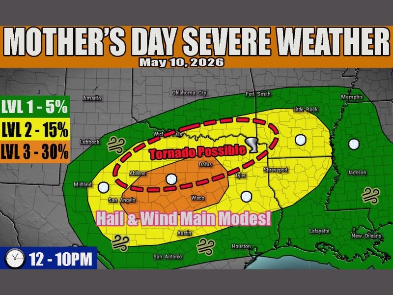
Very Large Hail, Straight Line Winds and Tornado Possible Across Central Texas Including Abilene, Dallas and Waco on Mother’s Day Sunday May 10 From Noon to 10PM Under Level 3 Risk
TEXAS — Widespread severe weather is setting up across central Texas on Mother’s Day, Sunday May 10, 2026, with a Level 3 of 5 Enhanced Risk zone introduced covering one of the most active severe weather setups of the season. Very large hail and straight line winds are the primary modes across the Level 3 core covering Abilene, San Angelo, Waco, and surrounding communities from noon through 10 PM.
A tornado is possible early in the event across northern Texas from Abilene into Dallas when storms have the best chance of remaining discrete before transitioning to linear modes.
Very Large Hail and Straight Line Winds Primary Threats Across Level 3 Core
The Level 3 Enhanced Risk orange core covers the most dangerous zone across central Texas, with very large hail and straight line winds identified as the dominant hazard modes. Abilene, San Angelo, Waco, and the surrounding central Texas corridor sit inside this highest risk zone through the afternoon and evening hours.
The synoptic environment strongly supports a quick transition to linear storm modes, which will shift the primary threat toward widespread straight line wind damage as storms organize into a larger complex through the afternoon.
Tornado Possible Early From Abilene Into Dallas When Discrete Storms Most Likely
The tornado potential is focused on the early portion of the event from noon into the early afternoon hours, when storms across northern Texas from Abilene through Dallas stand the best chance of remaining discrete and organized. A tornado developing during this window depends on storm interactions and favorable outflow boundaries lingering from overnight storm activity.
Overall tornado probability remains lower given the expected quick transition to linear storm mode, but the threat cannot be dismissed across the Abilene to Dallas corridor through the early afternoon.
Level 2 Slight Risk Extends Through Dallas, Tyler and Shreveport Into Arkansas
The broader Level 2 yellow zone pulls Wichita Falls, Dallas, Tyler, Shreveport, Little Rock, and surrounding communities into the Sunday severe weather picture. Storm activity beginning as early as noon and persisting through 10 PM means a prolonged and multi-hour severe weather window for the entire risk zone across Texas and neighboring states. Stay with NapervilleLocal.com for the latest weather updates and local forecast coverage.

I’ve lived in Naperville long enough to see how quickly our community changes — from new developments downtown to sudden shifts in our Midwest weather. Reporting on Naperville news and daily forecasts gives me the chance to keep neighbors informed about what really matters. My goal is simple: deliver clear, timely updates so you always know what’s happening in our city and what to expect from the skies above.