
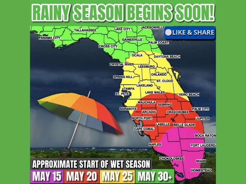
Rainy Season Arriving Across Florida From Miami and Fort Lauderdale Through Orlando Tampa and Jacksonville With Daily Downpours Expected Between May 15 and May 30
FLORIDA — Florida’s rainy season is just days away, with daily downpours set to return to communities across the state in a staggered timeline running from South Florida beginning around May 15 northward through Central and North Florida by May 30 and beyond.
The arrival of wet season is critically important this year, as a record 82 percent of the state is currently sitting under extreme or exceptional drought conditions. Wet season on average delivers roughly two thirds of Florida’s entire yearly rainfall, making this upcoming stretch one of the most anticipated weather pattern shifts of the year.
South Florida Including Miami Fort Lauderdale and Homestead First to See Rainy Season Around May 15
The southern tip of Florida is first in line for wet season onset, with the Miami, Fort Lauderdale, Boca Raton, and Homestead corridor expected to see daily downpours begin around May 15. This region historically leads the state into rainy season, driven by the intense heat and moisture that builds earliest across South Florida’s low-lying terrain and warm surrounding waters.
With extreme and exceptional drought gripping a record share of the state, the arrival of consistent daily rainfall across South Florida cannot come soon enough. Every inch of rainfall during the early weeks of wet season will be critical for drought recovery across this region.
South Central Florida Including Naples Cape Coral Sebring and Okeechobee Enters Wet Season Around May 20
The South-Central Florida corridor, covering communities including Naples, Cape Coral, Arcadia, Sebring, Okeechobee, Wauchula, and Palm City, is expected to transition into rainy season around May 20. This zone sits between the earliest and latest onset areas and will begin experiencing the shift from scattered frontal storms to daily afternoon and evening convective downpours during the third week of May.
The yellow zone on the outlook map covering areas including Tampa, St. Pete, Sarasota, Orlando, Lakeland, and Vero Beach follows closely behind with a Central Florida wet season start expected around May 25. These communities will begin seeing the daily coverage of afternoon thunderstorms that define Florida summers ramp up considerably by late May.
North Florida Including Tallahassee Jacksonville and Gainesville Enters Rainy Season May 30 and Beyond
North Florida communities including Tallahassee, Jacksonville, Gainesville, Panama City, Lake City, and Palm Coast are last in the staggered onset timeline, with wet season expected to begin around May 30 or later. The green zone covering North Florida typically takes the longest to transition into the daily rainfall pattern that the rest of the state enters earlier in the month.
While today’s scattered storms are tied to a passing front rather than true wet season convection, the pattern shift is close for all regions of Florida. Residents statewide should prepare for the return of daily afternoon downpours, and given the severity of the ongoing drought, the upcoming rainy season carries extra significance for water supply, agriculture, and wildfire risk reduction across the entire state. Stay with NapervilleLocal.com for the latest weather updates and local forecast coverage.

I’ve lived in Naperville long enough to see how quickly our community changes — from new developments downtown to sudden shifts in our Midwest weather. Reporting on Naperville news and daily forecasts gives me the chance to keep neighbors informed about what really matters. My goal is simple: deliver clear, timely updates so you always know what’s happening in our city and what to expect from the skies above.