
Strong to Severe Storms Damaging Winds and Hail Targeting Colorado and Front Range Including Denver Rockford and Eastern Plains With Rain and Snow Possible Sunday Night Into Monday
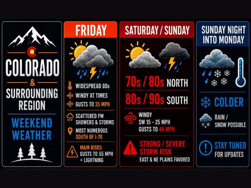
COLORADO — A very active and complex weather stretch is unfolding across Colorado and the surrounding region this weekend, with widespread 80s, scattered storms, and gusty winds Friday giving way to a strong to severe storm threat Saturday and Sunday before a dramatic colddown arrives Sunday night into Monday. Friday’s storms are most numerous south of I-70 and east of I-25 extending into western Kansas, with gusts reaching 55 mph and lightning as the primary risks.
Strong to severe thunderstorms this weekend are capable of producing damaging winds exceeding 70 mph, large hail at least 1.5 inches in diameter, and brief tornadoes cannot be ruled out across the most active zones.
Friday Brings Widespread 80s and Scattered Storms Most Numerous South of I-70
Friday features widespread 80s statewide with scattered afternoon and evening showers and storms developing across the region. Storm coverage is most numerous south of I-70 and east of I-25 extending into western Kansas, where gusts to 55 mph and dangerous lightning represent the primary hazards.
Winds will be gusty throughout the day with gusts reaching 35 mph even outside of storm activity, making Friday a breezy and unsettled start to the weekend across the Denver and Front Range corridor.
Saturday and Sunday Carry Strong to Severe Storm Risk Across East and Northeast Plains
Saturday and Sunday escalate the threat considerably as a storm approaches from the west, causing southwesterly mountain winds to clash with southeasterly surface winds along the Front Range and I-25 corridor. Temperatures range from 70s and 80s in the north to 80s and 90s across southern areas, with winds gusting to 40 mph through both days.
The east and northeast plains are the favored zone for the strongest and most severe storm activity Saturday and Sunday, with damaging winds exceeding 70 mph, large hail, and brief tornadoes all possible with the strongest cells.
Cold Front Sunday Night Brings Rain and Possible Wet Snow Into Monday Morning
Sunday night brings a dramatic pattern shift as a cold front plows through the region, pushing colder air southward and triggering additional rain development along and behind the boundary. Some of this precipitation could change over to wet snowfall going into Monday morning across higher elevations and potentially lower terrain depending on how quickly temperatures drop.
Barometric pressure-sensitive residents should begin taking precautions today and continue through Monday as the sharp pressure changes associated with this frontal passage move through the region. Stay with NapervilleLocal.com for the latest weather updates and local forecast coverage.

I’ve lived in Naperville long enough to see how quickly our community changes — from new developments downtown to sudden shifts in our Midwest weather. Reporting on Naperville news and daily forecasts gives me the chance to keep neighbors informed about what really matters. My goal is simple: deliver clear, timely updates so you always know what’s happening in our city and what to expect from the skies above.