
All Hazards Severe Weather Threat Across Illinois and Wisconsin Including Rockford Chicago and Milwaukee With Monday Carrying Enhanced Risk at 30 Percent
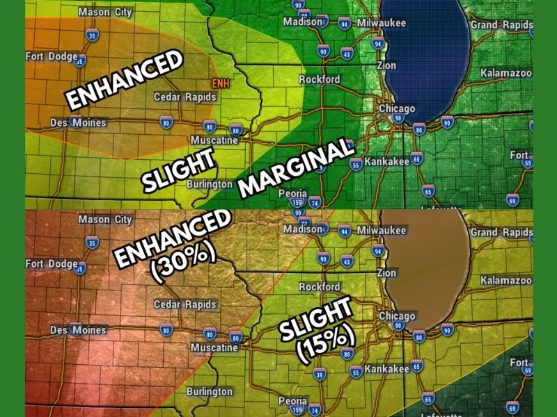
ILLINOIS — A warmer and more active weather pattern is arriving across Illinois and Wisconsin, bringing multiple rounds of showers and thunderstorms with several chances for severe weather from Friday night through Tuesday. Monday stands out as the most significant and concerning day of the entire stretch, carrying an Enhanced Risk at 30 percent severe probability across the Rockford corridor with all modes of severe weather in play. The other days carry lower Marginal and Slight risk levels, and while they deserve awareness, the overall concern outside of Monday is considerably lower.
Conditions clear out entirely by midweek, giving the region a well-deserved break after the extended active stretch.
Friday Night Through Sunday Brings Marginal and Slight Risks With Wind and Hail as Main Threats
Friday’s storm threat arrives after midnight carrying a Marginal Risk for most and a Slight Risk west of Rockford with wind and hail as primary hazards. Saturday’s threat arrives during the late afternoon and evening at Marginal Risk level statewide with wind as the main concern.
Sunday brings an early morning and very late night threat window with Marginal Risk for most and Slight Risk west and northwest of Rockford where wind and hail remain the primary concerns.
Monday Carries Enhanced Risk at 30 Percent With All Modes of Severe Weather in Play
Monday is by far the most dangerous day of the multi-day stretch and demands the most preparation across the region. An Enhanced Risk covering the Rockford corridor carries a 30 percent severe probability with tornadoes, large hail, and damaging winds all in play during the afternoon and evening hours.
Chicago, Milwaukee, and Madison fall within the broader Slight Risk zone at 15 percent on Monday, extending the significant threat across the entire northern Illinois and southern Wisconsin corridor.
Tuesday Closes the Active Stretch With Marginal Risk and Isolated Tornado Threat Southwest of Rockford
Tuesday brings the final round arriving mainly during early morning hours with a Marginal Risk for most and a Slight Risk southwest of Rockford. Isolated tornadoes are possible southwest of Rockford alongside widespread wind concerns across the broader area before the entire pattern clears by midweek. Stay with NapervilleLocal.com for the latest weather updates and local forecast coverage.

I’ve lived in Naperville long enough to see how quickly our community changes — from new developments downtown to sudden shifts in our Midwest weather. Reporting on Naperville news and daily forecasts gives me the chance to keep neighbors informed about what really matters. My goal is simple: deliver clear, timely updates so you always know what’s happening in our city and what to expect from the skies above.