
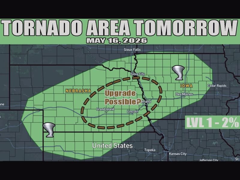
Tornado Possible Across Nebraska and Iowa Including Omaha Lincoln Sioux City and Des Moines With Upgrade Possible if Moisture and Storm Development Increase Saturday May 16
NEBRASKA — Nebraska and Iowa are the primary areas to watch for tornado potential on Saturday, May 16, 2026, with northern Kansas also in play as wind shear supports supercell structures across the outlined zone. A Level 1 risk at 2 percent tornado probability is in place, but an upgrade remains possible if confidence in storm development increases across the eastern Nebraska and Iowa corridor. One or two tornadoes are possible if favorable moisture and sustained storms come together Saturday afternoon.
Strong Cap and Late Forcing Limit Storm Confidence But Shear Supports Supercells
A strong atmospheric cap and late-arriving forcing are the two biggest factors limiting storm development confidence heading into Saturday. Moisture is not particularly deep across the region, which further suppresses the overall ceiling for widespread storm initiation.
Despite those limitations, wind shear values are sufficient to support supercell structures if any storm breaks through the cap during the afternoon hours.
Eastern Nebraska Into Iowa Holds the Best Tornado Potential With Upgrade Possible
The dashed upgrade zone centered over eastern Nebraska from Grand Island through Omaha and Lincoln stretching into Iowa represents the highest tornado potential area Saturday. Some guidance suggests deeper moisture pooling along a warm front in eastern Nebraska into Iowa, which would push tornado probabilities higher if that scenario verifies.
Communities from Omaha and Lincoln eastward through Sioux City and Des Moines should monitor updated forecasts closely as confidence evolves through the day.
Weather Awareness Essential Across Nebraska Iowa and Northern Kansas Saturday Afternoon
Residents across Nebraska, Iowa, and northern Kansas should have weather alerts active and shelter plans confirmed before Saturday afternoon arrives. Tornadoes in low-confidence setups can develop quickly and with limited warning when the atmosphere cooperates unexpectedly.
Checking updated forecasts Saturday morning will be critical as forecasters gain better clarity on moisture depth and storm initiation potential across the outlined zone. Stay with NapervilleLocal.com for the latest weather updates and local forecast coverage.

I’ve lived in Naperville long enough to see how quickly our community changes — from new developments downtown to sudden shifts in our Midwest weather. Reporting on Naperville news and daily forecasts gives me the chance to keep neighbors informed about what really matters. My goal is simple: deliver clear, timely updates so you always know what’s happening in our city and what to expect from the skies above.