
Egg Size Hail 70mph Gusts and Tornado Threat Targeting Nebraska Including Omaha Lincoln Sioux City and Grand Island With Storms Converging After 6PM Saturday Night
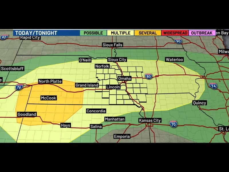
NEBRASKA — A loud and dangerous overnight severe weather setup is taking shape across Nebraska and surrounding areas, with storm chances increasing significantly after 6 PM Saturday night. Egg size hail, wind gusts exceeding 70 mph, and tornado potential are all on the table as storms develop to the south and west before converging on the region through the overnight hours. The tornado threat is most concerning near and south of I-80, where initial storms carry the highest rotation potential during the early evening window.
Storms Converge on Nebraska After 6PM Bringing Wind Hail and Tornado Threat Overnight
Storm activity increases rapidly after 6 PM as systems developing to the south and west track toward the Omaha, Lincoln, Grand Island, and Sioux City corridor. The convergence of multiple storm clusters heading into the overnight hours sets the stage for a prolonged and dangerous severe weather window across the region.
The worst of the threat is expected during the overnight hours, making this a particularly dangerous setup as many residents will be asleep when the most intense storms arrive.
Egg Size Hail and 70mph Gusts Possible With Worst Storms Across the Risk Zone
The strongest storms Saturday night are capable of producing egg size hail and wind gusts exceeding 70 mph across the outlined severe weather zone. These hazard levels are capable of causing significant damage to vehicles, roofs, and any exposed property across communities from Grand Island and Norfolk through Omaha and Lincoln.
The widespread risk zone covering Nebraska eastward toward Waterloo and Quincy confirms the broad geographic reach of tonight’s severe weather threat.
Tornado Potential Highest Near and South of I-80 With Initial Storm Development
Tornado potential exists with the initial round of storm development Saturday evening, particularly near and south of I-80 across Nebraska. The initial discrete storm phase before any upscale growth into a larger complex carries the highest tornado risk, making the early evening hours the most critical window for rotation potential across the corridor.
Residents across the entire outlined zone should have weather alerts active before 6 PM and know their shelter location well in advance of tonight’s converging storm threat. Stay with NapervilleLocal.com for the latest weather updates and local forecast coverage.

I’ve lived in Naperville long enough to see how quickly our community changes — from new developments downtown to sudden shifts in our Midwest weather. Reporting on Naperville news and daily forecasts gives me the chance to keep neighbors informed about what really matters. My goal is simple: deliver clear, timely updates so you always know what’s happening in our city and what to expect from the skies above.