
Storms Breaking the Heat Across Pennsylvania New Jersey and the Mid-Atlantic With 40 Degree Temperature Drop Expected Arriving 4PM to 9PM West to East Wednesday May 20
MID-ATLANTIC — A significant storm system is set to break the heat across Pennsylvania, New Jersey, and the broader Mid-Atlantic region Wednesday afternoon and evening, with storms arriving from west to east between 4 PM and 9 PM. The HRRR model valid at 1 AM Thursday shows intense storm activity sweeping through the region, and a dramatic 40 degree temperature drop is expected from this afternoon’s highs to Thursday morning’s readings. The storm line is moving from west to east making the afternoon hours the primary window for the western portions of the region and the evening hours for the eastern zones.
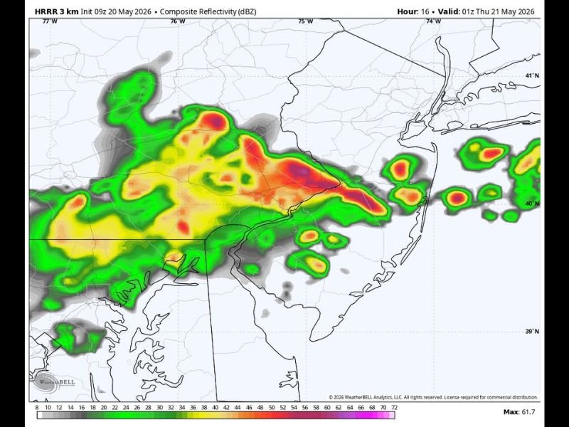
Storms Arrive West to East Between 4PM and 9PM Across the Region
The storm line currently shown on HRRR radar simulation is tracking from west to east across Pennsylvania and into New Jersey during the 4 PM to 9 PM window Wednesday. Western communities will feel the storm impacts during the earlier part of the window while eastern New Jersey and coastal areas see the activity arrive closer to the evening and into the overnight hours.
The composite reflectivity values on the HRRR model show intense red and orange returns indicating heavy rainfall and strong storm activity tracking across the densely populated corridor.
40 Degree Temperature Drop Expected From Wednesday Afternoon to Thursday Morning
One of the most dramatic aspects of today’s storm system is the 40 degree temperature swing expected between this afternoon’s warm readings and Thursday morning’s much cooler temperatures. This sharp cooldown following storm passage will make Thursday feel dramatically different from the heat building ahead of tonight’s storm line.
Residents should be prepared for a significant change in feel heading into Thursday morning across the entire Mid-Atlantic region.
Storm Line Pushes Heat Out and Ushers in Dramatically Cooler Pattern Overnight
The storm system sweeping through Wednesday evening effectively ends the current warm and humid pattern across Pennsylvania, New Jersey, and surrounding areas. Anyone with outdoor evening plans should reschedule or have an indoor backup ready before 4 PM as storm timing can vary and conditions can deteriorate quickly ahead of the main line arrival. Stay with NapervilleLocal.com for the latest weather updates and local forecast coverage.

I’ve lived in Naperville long enough to see how quickly our community changes — from new developments downtown to sudden shifts in our Midwest weather. Reporting on Naperville news and daily forecasts gives me the chance to keep neighbors informed about what really matters. My goal is simple: deliver clear, timely updates so you always know what’s happening in our city and what to expect from the skies above.