
Multiple Rounds of Heavy Rain and Storms Targeting the Southeast Including Memphis, Jackson, New Orleans, Atlanta, and Raleigh With 3 to Over 5 Inches Possible Over the Next 10 Plus Days
SOUTHEASTERN UNITED STATES — An extremely active sub-tropical jet stream is driving multiple rounds of rain and storms across the Southeast over the next 10 or more days, bringing widespread rainfall totals of at least 3 inches with higher amounts expected in several locations.
The threat corridor stretches from Mississippi and Louisiana through Tennessee, Georgia, and into the Carolinas, with daily afternoon and evening storm rounds expected to be a consistent pattern throughout the period. Pockets of sunshine will occur, but residents across the region should count on unsettled and wet conditions persisting well into the coming weeks.
Active Sub-Tropical Jet Fueling Relentless Multi-Round Storm Pattern Across the Southeast
An extremely active sub-tropical jet stream is the primary driver behind this prolonged wet pattern affecting the Southeast. This atmospheric feature is funneling continuous rounds of moisture and storm energy into the region, keeping rain chances elevated on a daily basis for 10 or more days.
Afternoon and evening storm rounds are expected to be the consistent timing each day throughout the period. While breaks of sunshine will occur between rounds, no extended dry stretch is anticipated for the foreseeable future across the affected corridor.
Rainfall Totals of 3 to Over 5 Inches Forecast From Mississippi Through the Carolinas
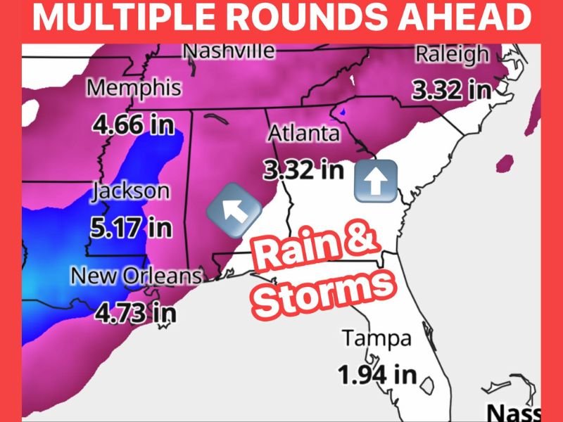
The heaviest rainfall totals are focused across Mississippi and Louisiana, where Jackson is forecast to receive 5.17 inches and New Orleans is projected to see 4.73 inches over the multi-round period. Memphis sits at 4.66 inches, placing the entire lower Mississippi Valley corridor at elevated flood risk as rounds of rain continue stacking on one another.
Farther east, Atlanta and Raleigh are both forecast to receive 3.32 inches through the period, keeping flood and nuisance water concerns active across Georgia and the Carolinas as well. Tampa sits at a lower projected total of 1.94 inches but remains within the broader storm corridor.
Jackson and New Orleans Carrying the Highest Flood Risk Through the 10-Day Period
With totals approaching and exceeding 5 inches, Jackson and New Orleans face the greatest cumulative flooding threat of any cities in the forecast zone. Repeated rounds of rain falling on ground that has little time to dry between events will accelerate runoff and increase both flash flood and urban flood risk significantly.
Residents in these communities should be especially vigilant about flood-prone roadways, low-lying neighborhoods, and drainage systems that may become overwhelmed as rainfall accumulates over the extended period. Preparation now is strongly advised before additional rounds arrive.
Daily Storm Rounds Through the 10-Day Window Demand Consistent Weather Awareness
With storms expected each afternoon and evening for the next 10 or more days, residents across the entire Southeast corridor need to build weather awareness into their daily routines. Travel plans, outdoor events, and any activities dependent on dry conditions should account for the high likelihood of storm activity each day.
Staying connected to local forecasts and monitoring any flood watches or warnings will be critical throughout this prolonged pattern. Conditions are expected to remain active and evolving as each new round of storms moves through the region.
Stay with NapervilleLocal.com for the latest weather updates and local forecast coverage.

I’ve lived in Naperville long enough to see how quickly our community changes — from new developments downtown to sudden shifts in our Midwest weather. Reporting on Naperville news and daily forecasts gives me the chance to keep neighbors informed about what really matters. My goal is simple: deliver clear, timely updates so you always know what’s happening in our city and what to expect from the skies above.