
Multi-Round Heavy Rainfall and Flooding Concerns Targeting Texas and Gulf Coast Region With 5 to Nearly 10 Inches of Total Precipitation Possible Through Tuesday May 26
TEXAS AND GULF COAST — A multi-round rainfall event is unfolding across Texas and the broader Gulf Coast region, with the heaviest and most flood-threatening rain expected to arrive this weekend and continue through Tuesday, May 26, 2026. Total precipitation accumulations of 5 to nearly 10 inches are forecast across widespread areas, with isolated pockets along the southern Texas coast pushing even higher. Tuesday night’s first round of storms was manageable, but forecasters warn the worst is still ahead as flooding concerns grow significantly into the weekend.
Heaviest Rain and Flooding Threat Peaks This Weekend Across the Region
While the first round of overnight rain moved through without major issues, forecasters now believe the most significant rainfall is still ahead for the region. The weekend period carries the greatest flooding concern as additional rounds of storms push onshore and inland.
The WPC 2.5km model initialized Wednesday morning shows total precipitation valid through 6z Tuesday, May 26, with values stacking well above 5 inches across nearly the entire region. The setup points to a prolonged and heavy rainfall pattern that will not clear quickly.
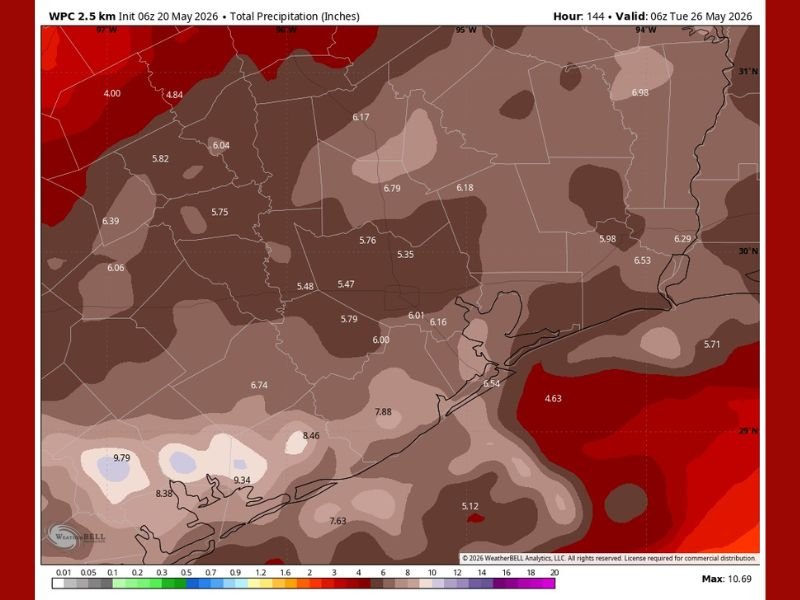
Rainfall Totals of 5 to 10 Inches Widespread From Central Texas to the Coast
Across central and southeastern Texas, widespread totals of 5 to 7 inches are forecast through the valid period, with values of 5.47 to 6.74 inches common across the Houston metro corridor and surrounding counties. Areas farther inland are not spared, with totals ranging from 5.75 to 6.17 inches across north and central Texas.
The most extreme totals are focused along the southern Texas coast, where values of 7.88, 8.46, 9.34, and 9.79 inches are modeled, with the map maximum reaching 10.69 inches. These amounts carry significant flash flood and riverine flood potential for communities in those areas.
Coastal and Southern Texas Facing the Most Extreme Accumulation Totals
The southern coastal zone stands out as the highest-risk area for flooding over the next week, with rainfall totals approaching and potentially exceeding 10 inches in localized spots. Saturated ground from earlier rounds will only increase runoff rates and flood risk as the weekend storms arrive.
Areas near the coast where totals of 9 to nearly 10 inches are modeled face the greatest threat for prolonged or significant flooding events. Residents in these zones should begin preparing now and monitor any flood watches or warnings issued by local officials.
Multiple Storm Rounds Over the Next Week Demand a Prepared and Alert Response
With multiple rounds of rain expected over the coming week, any flooding impacts from early rounds will compound as additional rainfall arrives on already-saturated ground. Residents across the region should avoid unnecessary travel during heavy rain periods and stay clear of flooded roadways.
Having an emergency plan, monitoring local alerts, and understanding flood-prone areas nearby are critical steps for anyone living within the forecast corridor this week. Conditions are expected to evolve quickly, particularly as the weekend approaches. Stay with NapervilleLocal.com for the latest weather updates and local forecast coverage.

I’ve lived in Naperville long enough to see how quickly our community changes — from new developments downtown to sudden shifts in our Midwest weather. Reporting on Naperville news and daily forecasts gives me the chance to keep neighbors informed about what really matters. My goal is simple: deliver clear, timely updates so you always know what’s happening in our city and what to expect from the skies above.