
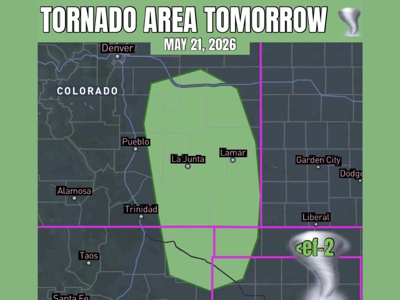
Tornado Threat From Discrete Supercells Across Southeastern Colorado Including La Junta and Lamar With Less Than EF-2 Tornado Potential Thursday May 21
SOUTHEASTERN COLORADO — A tornado threat is in the forecast for southeastern portions of Colorado on Thursday, May 21, 2026, as atmospheric conditions favor the development of discrete supercells across the high plains. The risk zone covers a broad corridor including La Junta and Lamar, with any tornado that develops expected to remain below EF-2 intensity. While the overall chance stays slim, residents across the affected area are urged to remain weather-aware throughout the day.
Discrete Supercell Development Favored Across the Southeastern Colorado High Plains
A ripple of energy moving off the higher terrain is expected to initiate storm development across southeastern Colorado on Thursday. Atmospheric shear values in the region favor supercell organization, giving any storms that fire the potential to become tornado-capable during the afternoon hours.
Moisture will pinch up along the back side of a cold front and into the high plains, providing at least a baseline level of fuel for storm development. The setup is not explosive, but it is sufficient for a couple of discrete supercells to develop across the corridor.
Less Than EF-2 Tornado Risk Covers the La Junta and Lamar Corridor
The tornado threat across the highlighted risk zone is capped at less than EF-2 intensity based on current forecasting data. The corridor of greatest concern runs through southeastern Colorado, centering on the communities of La Junta and Lamar.
Storms may be somewhat high-based due to the atmospheric profile, which could limit overall tornado potential. Forecasters note there is at least a slim chance something significant develops, and the threat should not be dismissed entirely.
Cold Front Boundary to Play a Key Role in Storm Initiation and Focus Thursday
The positioning of a cold front across the region will be a critical factor in determining where and when storms fire Thursday afternoon. Moisture pooling along this boundary could help focus storm development into a relatively narrow corridor across southeastern Colorado.
If storms develop along or near the frontal boundary, the combination of shear and available instability would support supercell characteristics. Residents from Pueblo eastward through La Junta and toward the Kansas border should monitor conditions closely through the evening.
Outdoor Plans Inside the Tornado Risk Zone Need a Weather Safety Component Thursday
Anyone with outdoor plans inside the southeastern Colorado tornado risk zone on Thursday should build a weather safety plan into their day. Identifying a sturdy shelter in advance and having access to reliable weather alerts is strongly recommended.
The slim but real tornado chance means conditions could change quickly during the afternoon. Staying connected to local forecasts and having an action plan ready before heading out is the safest approach for Thursday.
Stay with NapervilleLocal.com for the latest weather updates and local forecast coverage.

I’ve lived in Naperville long enough to see how quickly our community changes — from new developments downtown to sudden shifts in our Midwest weather. Reporting on Naperville news and daily forecasts gives me the chance to keep neighbors informed about what really matters. My goal is simple: deliver clear, timely updates so you always know what’s happening in our city and what to expect from the skies above.