
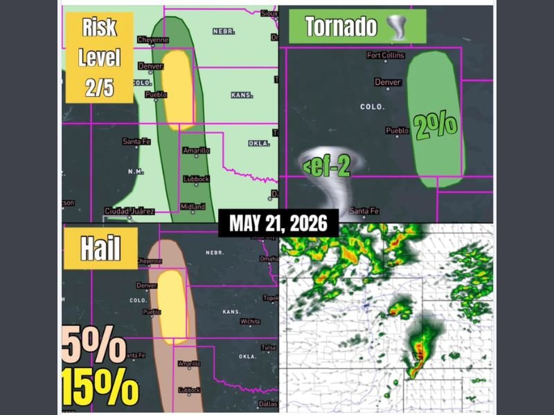
Supercell Threat With Hail, Gusty Winds, and Brief Tornado Window Targeting Eastern Colorado Including Denver and Pueblo at Risk Level 2 of 5 Thursday May 21
EASTERN COLORADO — A severe weather setup is in focus across the high plains of eastern Colorado on Thursday, May 21, 2026, where at least a couple of supercells are possible capable of producing all hazard modes. The overall risk is rated at Level 2 out of 5, with high-based hailers expected to be the dominant storm mode given moisture depth running a bit on the dry side through the afternoon. A brief tornado window opens later in the evening as moisture increases, while scattered storms elsewhere across the broader region may produce gusty winds and small hail.
High-Based Hailers Expected as Dominant Storm Mode Across Eastern Colorado Thursday
With moisture depth running slightly on the dry side, high-based supercells capable of producing hail are forecast to be the primary storm mode across eastern Colorado Thursday afternoon. The hail threat carries a 15 percent probability across the core zone covering Denver southward through Pueblo, with a broader 5 percent hail probability extending across a wider corridor.
Any supercells that develop will have sufficient atmospheric support to organize and sustain themselves across the high plains through the afternoon hours. Residents across the Denver to Pueblo corridor should be prepared for hail-producing storms during the peak afternoon heating window.
Brief Tornado Window Opens During Evening Hours as Moisture Increases
While tornado chances remain low through the afternoon, a short window for a brief tornado develops later in the evening as moisture depth increases across the region. The tornado probability sits at 2 percent across the risk zone covering Fort Collins south through Denver and Pueblo, with any tornado expected to remain below EF-2 intensity.
The evening moisture increase is the key factor that could allow at least a slim tornado threat to materialize. Residents across the Front Range and eastern plains corridor should remain weather-aware through the evening and not let their guard down after the afternoon storm rounds pass.
Gusty Winds and Pocket Change Hail Possible With Scattered Storms Across the Broader Region
Beyond the primary eastern Colorado supercell threat, scattered storms developing across the broader surrounding region carry the potential for gusty winds and small hail. These storms are not expected to reach the same organized severe potential as those across the high plains but can still produce brief hazardous conditions.
Staying connected to local alerts and having a shelter plan ready through both the afternoon and evening hours is the safest approach for anyone across eastern Colorado and surrounding areas on Thursday. Stay with NapervilleLocal.com for the latest weather updates and local forecast coverage.

I’ve lived in Naperville long enough to see how quickly our community changes — from new developments downtown to sudden shifts in our Midwest weather. Reporting on Naperville news and daily forecasts gives me the chance to keep neighbors informed about what really matters. My goal is simple: deliver clear, timely updates so you always know what’s happening in our city and what to expect from the skies above.