
Fresh Storm Round Hitting Already Saturated Houston and Southern Brazoria County With Widespread Heavy Rainfall Threat Escalating Through Memorial Day Weekend
HOUSTON AND SURROUNDING REGION — A fresh round of storms is moving into the greater Houston region on Thursday, May 21, 2026, targeting areas south of the city including southern Brazoria County, which has already absorbed significant rainfall in recent days. Friday storms will remain more scattered, but the threat escalates considerably heading into Memorial Day Weekend when widespread heavy rainfall is expected to ramp up across the entire region. Residents across the Houston corridor are urged to prepare now before conditions worsen significantly over the coming days.
Southern Brazoria County Targeted Again as Ground Remains Saturated From Prior Rainfall
Southern Brazoria County is in the direct path of Thursday’s incoming storm round and has already been hard-hit by recent rainfall accumulation. Communities including Lake Jackson and Angleton face the highest immediate risk as new storm energy pushes into already-saturated ground through the day.
With drainage systems and soil moisture already at capacity across the southern zones, even moderate additional rainfall carries an elevated flood risk. Residents in these communities should remain on alert for rapid water rises throughout Thursday.
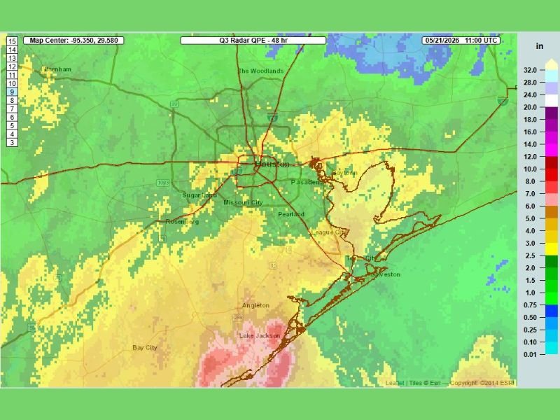
48-Hour Radar QPE Showing Widespread 3 to 7 Inch Totals Across the Houston Metro
The 48-hour radar QPE analysis valid through 11:00 UTC May 21 shows widespread totals of 3 to 5 inches blanketing the Houston metro including Sugar Land, Pearland, Pasadena, League City, and Texas City. Heavier pockets of 5 to 7 inches are concentrated across southeastern portions of the corridor pushing toward the coast.
The most extreme totals are clustered across southern Brazoria County, where values climb into the highest ranges on the QPE scale. This existing rainfall load leaves little capacity in the region to absorb what is still ahead.
Widespread Heavy Rainfall Threat Ramps Up Significantly Over Memorial Day Weekend
Friday will bring scattered storm activity before conditions deteriorate more broadly over Memorial Day Weekend. Widespread heavy rainfall arriving on top of already-saturated ground creates a high-risk flooding setup for the entire Houston region through the holiday period.
Monitoring local flood warnings, avoiding flooded roadways, and having an emergency plan in place before the weekend are strongly advised for all residents across the Houston area. Stay with NapervilleLocal.com for the latest weather updates and local forecast coverage.

I’ve lived in Naperville long enough to see how quickly our community changes — from new developments downtown to sudden shifts in our Midwest weather. Reporting on Naperville news and daily forecasts gives me the chance to keep neighbors informed about what really matters. My goal is simple: deliver clear, timely updates so you always know what’s happening in our city and what to expect from the skies above.