
Bowing Storm Line Moving Through Houston and Southeast Texas Including Beaumont and Corpus Christi Early Wednesday With Second Line to the South and Warmer Weekend Ahead
HOUSTON AND SOUTHEAST TEXAS — A bowing line of thunderstorms moved through the Houston region early Wednesday, May 27, 2026, pushing offshore as the main line of storms tracks along the Southeast Texas coastline toward Beaumont, Port Arthur, and Sabine Pass. A second storm line is also visible to the south near Corpus Christi and the Victoria corridor, though forecasters believe this event will be the final serious weather disturbance for the region for a while as warmer and sunnier conditions are expected to take hold heading into the weekend.
Main Bowing Storm Line Clearing Houston and Tracking Offshore Wednesday Morning
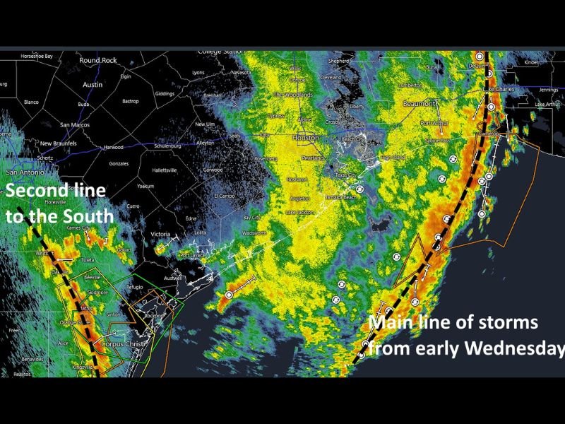
Radar shows the main line of early Wednesday storms, labeled on the image, pushing through the Houston metro and tracking southeastward along the coast toward Beaumont and Port Arthur. The bowing line structure indicates organized wind-driven storm motion, but the system is exiting the region and roads should be in good shape for the morning commute across the Houston area.
The heaviest storm cores are concentrated along the coastal zone from Houston through Beaumont, with yellow and red radar signatures indicating moderate to heavy rainfall rates within the most active portions of the departing line. The bulk of the storm impacts from this main line are already behind the Houston metro as of early Wednesday morning.
Second Storm Line Visible to the South Near Corpus Christi and Victoria Corridor
A second line of storms is visible to the south on radar, positioned near Corpus Christi, Victoria, and the surrounding south Texas coastal zone. This secondary line will need to be monitored through the morning hours, though overall the severe threat from both lines is considered low as the systems continue their eastward and offshore progression.
Communities from Corpus Christi through Port Lavaca and Victoria should remain weather aware through the morning as the secondary line moves through the area.
Warmer and Sunnier Conditions Expected to Build Into Houston Region This Weekend
Following Wednesday’s storm activity, forecasters are signaling a welcome pattern change for the Houston region as warmer and sunnier conditions are expected to arrive heading into the weekend. This represents a meaningful break from the prolonged and active wet pattern that has impacted the region throughout the prior week and over the Memorial Day holiday period. Stay with NapervilleLocal.com for the latest weather updates and local forecast coverage.

I’ve lived in Naperville long enough to see how quickly our community changes — from new developments downtown to sudden shifts in our Midwest weather. Reporting on Naperville news and daily forecasts gives me the chance to keep neighbors informed about what really matters. My goal is simple: deliver clear, timely updates so you always know what’s happening in our city and what to expect from the skies above.