
Strong to Severe Storms With Damaging Wind Gusts and Hail Possible Across North and Central Georgia Including Atlanta, Macon, and Nashville Tennessee Corridor Monday June 1
NORTH AND CENTRAL GEORGIA — Following rounds of scattered showers and storms through the weekend, a chance for strong to severe storms emerges across north and central Georgia on Monday, June 1, 2026, with damaging wind gusts and hail as the primary hazards. The severe threat zone covers a broad corridor from the Tennessee border and Nashville area southward through Atlanta and Macon, though forecasters are clear this will not be a major severe weather outbreak. Rather, some of the stronger individual storms that develop Monday could pack enough punch to produce damaging winds and hail across the affected zone.
Severe Threat Zone Stretches From Nashville Corridor Through Atlanta and Into Macon
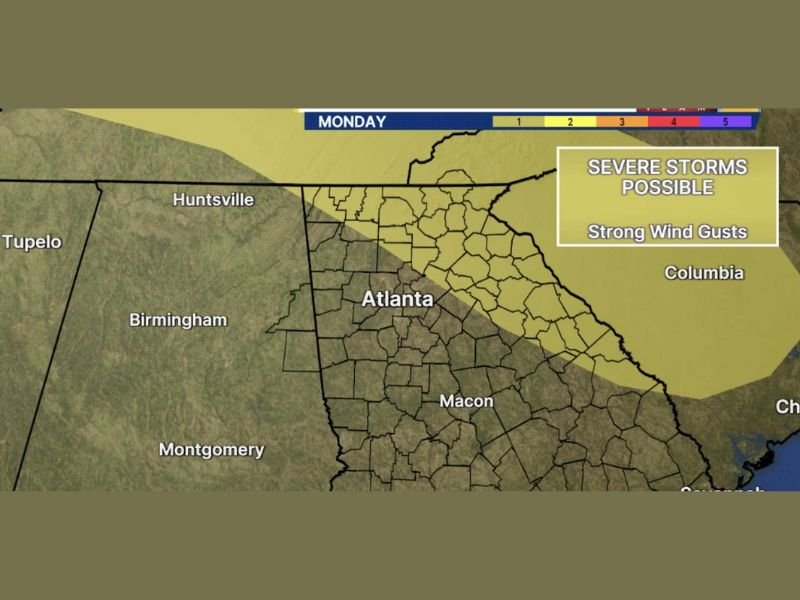
The severe threat map shows a Level 1 risk zone blanketing a wide area from near Nashville and the Tennessee border southward through the entire north and central Georgia corridor. Atlanta sits squarely within the active risk zone alongside surrounding communities including Huntsville, Rome, and the broader metro area extending southward through Macon toward the coastal plain zones.
The broad geographic footprint of Monday’s risk zone means a large and heavily populated area needs to maintain weather awareness through the day. The most active storm coverage is expected during the afternoon and evening hours when daytime heating maximizes instability across the region.
Damaging Wind Gusts and Hail the Primary Severe Hazards Monday Across the Region
Strong wind gusts and hail are specifically identified as the hazards of concern with Monday’s stronger storm cells across north and central Georgia. While the overall severe weather probability is low and no outbreak is expected, individual supercell or organized storm structures that do develop will be capable of producing brief but impactful wind damage and hail accumulation.
Communities from Huntsville and Tupelo on the western edge through Atlanta, Columbia, and toward the coastal zones on the eastern edge all fall within the Level 1 severe risk area for Monday.
Weekend Scattered Activity Giving Way to Monday Severe Chance Across Georgia
Saturday and Sunday bring scattered shower and storm rounds across the region before Monday’s more organized severe weather threat arrives. Residents across the Atlanta metro and surrounding north Georgia communities should stay connected to local forecast updates through the weekend as Monday’s setup comes into sharper focus. Stay with NapervilleLocal.com for the latest weather updates and local forecast coverage.

I’ve lived in Naperville long enough to see how quickly our community changes — from new developments downtown to sudden shifts in our Midwest weather. Reporting on Naperville news and daily forecasts gives me the chance to keep neighbors informed about what really matters. My goal is simple: deliver clear, timely updates so you always know what’s happening in our city and what to expect from the skies above.