
Very Large Hail Over 2 Inches and Couple of Tornadoes Possible Across the Dakotas With Northwest South Dakota at Greatest Risk Tuesday June 2nd
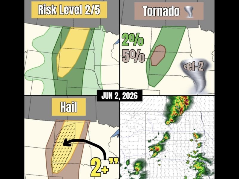
DAKOTAS — Very large hail and a couple of tornadoes are possible across the Dakotas Tuesday June 2nd, with northwest South Dakota carrying the highest risk where shear and instability are maximized under a Risk Level 2 of 5 outlook. The tornado probability has been upgraded to a 5 percent chance within a concentrated brown hatched zone centered over northwest South Dakota, with a broader 2 percent tornado probability extending across the larger green risk corridor.
Any tornadoes that develop are expected to remain below EF-2 intensity, but very large hail exceeding 2 inches in diameter represents the dominant and most widespread threat across the entire risk zone.
Northwest South Dakota the Bullseye Where Shear and Instability Peak
Northwest South Dakota sits at the center of the upgraded severe weather setup, where the combination of maximum wind shear and atmospheric instability creates the most favorable environment for significant supercell development.
The 5 percent tornado probability zone is tightly focused over this area, indicating that forecasters have elevated confidence in at least a couple of discrete tornado-producing supercells in this specific corridor. Radar is already showing organized convective activity firing along a north-south oriented line tracking through the primary threat zone.
Hail Exceeding 2 Inches the Primary Threat Across the Full Risk Corridor
The hail threat map shows a heavily hatched yellow zone covering the length of the risk area through the Dakotas, with hail sizes of 2 inches or greater expected across the full corridor wherever supercells develop. Hail of this magnitude causes significant damage to vehicles, rooftops, crops, and livestock, and residents within the yellow and brown zones should move vehicles to covered shelter before storms develop during the afternoon hours. The hatched designation signals that very large hail is not just possible but considered likely in the strongest cells.
Supercells Further North Favored Behind Surface Front as Large Hail Producers
Further north across North Dakota, supercells are expected to develop primarily behind the surface front, positioning them as predominantly large hail producers rather than tornado threats. However, if any storm manages to cross to the other side of the front, tornado potential increases immediately for that cell. Residents across both states should remain weather-aware throughout the afternoon and evening hours as the supercell threat evolves.
Stay with NapervilleLocal.com for the latest weather updates and local forecast coverage.

I’ve lived in Naperville long enough to see how quickly our community changes — from new developments downtown to sudden shifts in our Midwest weather. Reporting on Naperville news and daily forecasts gives me the chance to keep neighbors informed about what really matters. My goal is simple: deliver clear, timely updates so you always know what’s happening in our city and what to expect from the skies above.