
Stormy Pattern With Heavy Showers and Thunderstorms Targeting Houston and Southeast Texas Through Saturday Into Possibly Sunday With Rainfall Totals Reaching 2 Plus Inches
HOUSTON, TEXAS — A multi-day stormy pattern is set to descend upon Houston and the greater Southeast Texas region through Saturday and possibly into Sunday, bringing widespread showers and thunderstorms with rainfall totals projected to reach 2 inches or more across a large portion of the area.
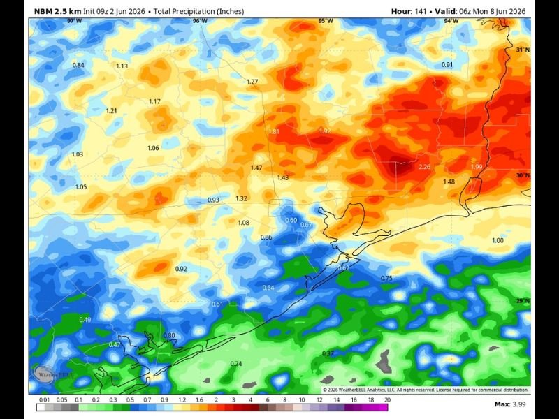
The NBM 2.5 km precipitation model initialized Tuesday June 2nd shows deep orange and red shading covering much of the Houston metro corridor with values ranging from 1.43 to 2.26 inches through the valid period ending Monday June 8th. Serious flooding is not anticipated at this time, but the persistent shower and thunderstorm pattern will demand weather awareness across the coming days.
Afternoon Hours Carry the Greatest Storm Activity Through the Multi-Day Period
The heaviest storm activity is expected to concentrate during the afternoon hours each day as daytime heating fuels convective development across the region. This pattern will repeat through Saturday with daily rounds of showers and thunderstorms particularly impactful during the midday through evening timeframe. Residents and commuters should build weather flexibility into afternoon plans for multiple consecutive days through the weekend.
Rainfall Totals of 1.5 to 2.26 Inches Projected Across the Houston Metro Corridor
The precipitation model shows the highest rainfall totals concentrated north and northeast of central Houston, with values of 1.81 to 2.26 inches depicted in the deepest orange and red zones across the metro corridor. Central Houston and areas near Galveston Bay are projected to receive between 0.60 and 1.08 inches, while locations further south along the coast sit in the lighter blue and green range below 0.75 inches. The axis of heaviest rainfall sits inland across the northern Houston suburbs through this entire multi-day period.
No Serious Flooding Expected but Weather Awareness Required Through the Weekend
Despite the multi-day nature of this stormy pattern, forecasters are not anticipating serious flooding concerns for the Houston area at this time. The rainfall is expected to be spread across several days rather than concentrated in a single high-impact event, which reduces the flood risk significantly. Residents should nonetheless remain weather-aware each afternoon through Saturday and monitor conditions as individual storm cells could still produce briefly heavy downpours.
Stay with NapervilleLocal.com for the latest weather updates and local forecast coverage.

I’ve lived in Naperville long enough to see how quickly our community changes — from new developments downtown to sudden shifts in our Midwest weather. Reporting on Naperville news and daily forecasts gives me the chance to keep neighbors informed about what really matters. My goal is simple: deliver clear, timely updates so you always know what’s happening in our city and what to expect from the skies above.