
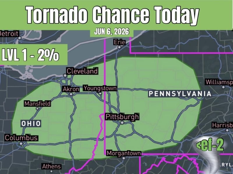
Brief Tornado Chance Across Eastern Ohio and Western Pennsylvania Including Cleveland Akron Youngstown and Pittsburgh Saturday June 6th
EASTERN OHIO AND WESTERN PENNSYLVANIA — A low-end but non-zero tornado chance exists across eastern Ohio and western Pennsylvania Saturday June 6th, with a Level 1 two percent tornado probability zone covering a broad area from Mansfield and Cleveland through Akron, Youngstown, and Pittsburgh. There is just enough atmospheric spin and instability along a surface boundary that storms could briefly rotate if they develop across the risk corridor today.
Any tornadoes that do occur are expected to remain below EF-2 intensity, keeping this in the brief and weak category rather than a significant tornado threat.
Level 1 Two Percent Zone Covers Eastern Ohio Through Western Pennsylvania
The green tornado probability zone on the June 6th outlook map stretches from the Mansfield and Columbus corridor in central Ohio northeastward through Cleveland, Akron, and Youngstown, then extending across the state line into western Pennsylvania through Pittsburgh and toward Erie. The risk footprint is sizeable geographically, but the overall probability remains low at the Level 1 two percent threshold.
Communities across the entire green zone should remain weather aware through the day and have a way to receive warnings if storms develop and rotate.
Surface Boundary Providing Just Enough Spin for Brief Storm Rotation
The primary driver of today’s tornado potential is a surface boundary draped across the region that is providing marginal but sufficient wind shear to support brief storm rotation. Forecasters describe this as a low-end day overall, with most guidance suggesting storms may struggle to fully organize into sustained supercell structures.
However, enough instability exists alongside the boundary that any storm that does fire could produce a brief spin-up tornado before weakening.
Stay Weather Aware Across the Risk Zone Through the Afternoon and Evening
Residents across eastern Ohio and western Pennsylvania from Cleveland and Akron through Youngstown, Pittsburgh, and Morgantown should keep a weather app active and emergency alerts enabled through Saturday. The tornado threat is low probability but real enough that awareness and preparedness are warranted across the full Level 1 zone.
Brief tornadoes can develop and dissipate quickly, making advance preparation the most effective safety strategy for today’s setup. Stay with NapervilleLocal.com for the latest weather updates and local forecast coverage.

I’ve lived in Naperville long enough to see how quickly our community changes — from new developments downtown to sudden shifts in our Midwest weather. Reporting on Naperville news and daily forecasts gives me the chance to keep neighbors informed about what really matters. My goal is simple: deliver clear, timely updates so you always know what’s happening in our city and what to expect from the skies above.