
Level 4 Moderate Risk Severe Weather Outbreak Targets Eastern Iowa, Northern Illinois, and Chicago With Damaging Winds and Strong Tornadoes in Two Rounds Today
MIDWEST — The Storm Prediction Center has upgraded eastern Iowa and northern Illinois to a Level 4 of 5 Moderate Risk for severe weather today, Thursday June 11, one of the rarest risk levels issued in any given year. The threat is already in motion with a bowing line of storms pushing east-northeast through midday, and a second more powerful round expected this afternoon and evening as a cold front fires new storms tracking toward Lake Michigan.
Round One Already Moving — Tornado Risk Increasing Through Midday
A bowing line of storms that fired overnight carries a history of severe wind gusts from Nebraska into Iowa and is currently pushing east-northeast. As this line advances, the tornado risk is increasing alongside the wind threat, making the midday hours dangerous across eastern Iowa and northern Illinois.
Residents in the path of this initial line should already have weather alerts active and shelter plans finalized. Do not wait for the second round to take this seriously — the first wave is capable of producing significant impacts.
Round Two This Afternoon — Damaging Winds and Strong Tornadoes
As the cold front fires new storms this afternoon and evening, the low-level jet cranks back up and a new line is expected to march toward Lake Michigan, cutting across Illinois, Indiana, and Lower Michigan. Damaging winds are the headline threat with this second round, but strong tornadoes are also on the table.
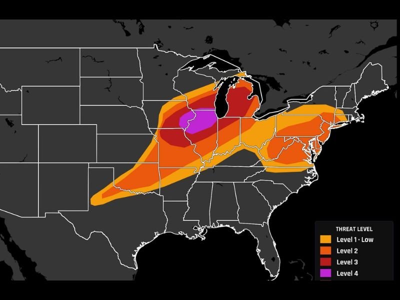
The Level 4 zone shown in purple on the SPC outlook is centered over northern Illinois and extends into southern Wisconsin, with the broader Level 4 red zone covering eastern Iowa through the Chicago metro corridor. Anyone within this zone faces a high probability of encountering severe weather today.
Keep Your Phone Close and Plan Ready All Day
From eastern Iowa through Chicago and into southern Wisconsin, today demands full weather awareness from morning through evening. Warnings will be issued, and both tornado warnings and severe thunderstorm warnings must be acted upon immediately.
Keep phones charged, alerts enabled, and know your nearest shelter location before storms arrive. Stay with NapervilleLocal.com for the latest weather updates and local forecast coverage.

I’ve lived in Naperville long enough to see how quickly our community changes — from new developments downtown to sudden shifts in our Midwest weather. Reporting on Naperville news and daily forecasts gives me the chance to keep neighbors informed about what really matters. My goal is simple: deliver clear, timely updates so you always know what’s happening in our city and what to expect from the skies above.