
Cooler Temps and Gusty 40 MPH Winds Bring Elevated Fire Danger Across Colorado and the Front Range Before Heat Rebounds and Storms Return This Weekend
COLORADO — A cold front that pushed through late Wednesday night is bringing noticeably cooler and windier conditions across Colorado and the surrounding region this Thursday, June 11. While temperatures are significantly lower than Wednesday’s scorching readings, gusty winds and dry conditions are maintaining elevated fire danger across multiple zones today. The cooler relief is short-lived, with heat returning Friday into Saturday before storm chances increase Sunday and a more significant cooldown arrives next week.
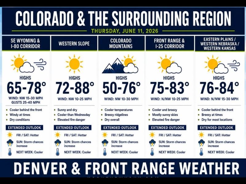
Gusty Winds and Elevated Fire Danger Across Multiple Zones Today
The most significant concern today despite the cooler temperatures is the wind and fire danger combination. SE Wyoming and the I-80 Corridor will see northwest winds of 15 to 30 mph with gusts reaching 25 to 40 mph, with highs in the 65 to 78°F range. Dry conditions across this zone make fire starts a real concern through the day.
The Front Range and I-25 Corridor is forecast to reach 75 to 83°F with north and northwest winds at 10 to 25 mph, elevated fire danger, and mostly sunny skies. The Western Slope climbs to 72 to 88°F with northwest winds at 10 to 25 mph and elevated fire danger as well. Residents across all of these zones should avoid any activity that could spark a fire today.
Cooler Across the Mountains With Breezy Ridgelines
The Colorado Mountains are seeing the most dramatic cooldown, with highs ranging from 50 to 76°F depending on elevation. Northwest winds at 10 to 30 mph are keeping ridgelines breezy, and conditions are dry overall across the mountain zones today.
The Eastern Plains, western Nebraska, and western Kansas are forecast to top out at 76 to 84°F with northerly winds at 15 to 30 mph and dry conditions for most locations.
Heat Returns Friday Before Storm Chances Increase Sunday
The comfortable Thursday temperatures are only a brief pause. Heat rebuilds across the entire region Friday into Saturday with widespread 80s and 90s returning. Storm chances then increase Sunday ahead of a stronger cold front, with the best precipitation window falling late Saturday through Monday and much cooler conditions arriving next week. Stay with NapervilleLocal.com for the latest weather updates and local forecast coverage.

I’ve lived in Naperville long enough to see how quickly our community changes — from new developments downtown to sudden shifts in our Midwest weather. Reporting on Naperville news and daily forecasts gives me the chance to keep neighbors informed about what really matters. My goal is simple: deliver clear, timely updates so you always know what’s happening in our city and what to expect from the skies above.